
Monday, October 24th, 2016
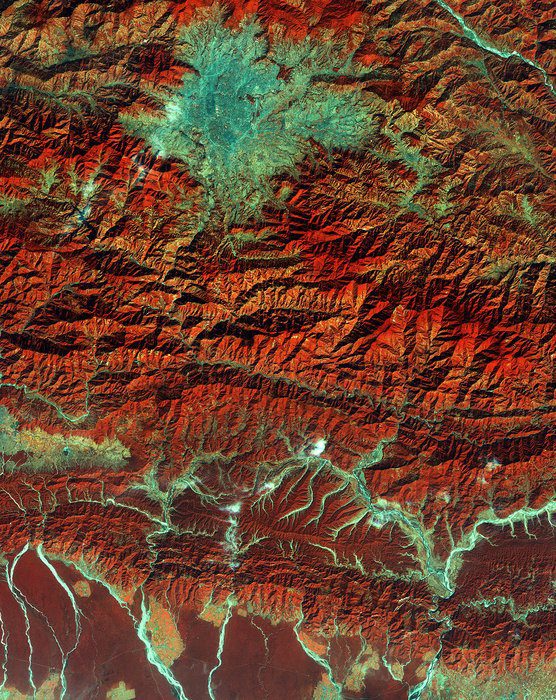
The European Space Agency (ESA) Copernicus Sentinel satellite captured this false-color image of part of Nepal, including its capital city, Kathmandu, and the Himalayan foothills. Vegetation appears red, while waterways and buildings appear light green and blue....

Thursday, August 13th, 2015
Crowdsourcing has added a new dimension to Nepal’s disaster response capability following the massive earthquake that struck this Himalayan country on 25 April, killing more than 8,000 people, injuring thousands and leaving tens of thousands displaced. Government...
Tuesday, January 10th, 2012
Fire is integral component of environmental systems throughout the world, including the Himalayas. Understanding fire patterns is...
Thursday, November 24th, 2011
A Nepali researcher with the University of Arizona in the United States claims to have developed the most exhaustive Geographic Information System (GIS) database for Nepal on his own. Dr Tank Ojha -- a one-time officer with the...
Thursday, July 21st, 2011
Nepal has ordered a new survey of Mount Everest to end the "confusion" over the exact height of the world's highest mountain, a government spokesman has said. The official overall height of Everest is designated as 8,848m (29,029ft). But...
Tuesday, April 12th, 2011
Dr. Nirmal H. Rajbhandari, Director General, Department of Department of Hydrology and Meteorology of the Government of Nepal, received hydrological and meteorological equipment worth two crore Nepalese Rupees from Dr Andreas Schild, Director General of ICIMOD, under...
Wednesday, March 30th, 2011
SuperGeo Technologies officially announced its latest partner in Nepal, where SeaGate Institute of Technology is authorized to distribute SuperGIS series software. Situated in Kathmandu, the capital of Nepal, SeaGate Institute of Technology offers services and training related to...
Monday, January 24th, 2011
For the first time in Nepal, a wild tiger fitted with satellite collar was translocated from the Chitwan National Park (CNP) to Bardia National Park (BNP) today. CNP authorities had rescued the injured male tiger from the...