Asian Surveying & Mapping
Breaking News
Australian Space Agency funds development of aerospace-grade GNSS receiver
The Australian Space Agency has funded the development of...
Continuity risks for Australian EO data access
A new report details the widespread use of Earth...
China launches new remote sensing satellite
JIUQUAN, April 15 (Xinhua) -- China on Monday launched...
7.4-Magnitude Earthquake Strikes Taiwan
A major, 7.4-magnitude earthquake struck the eastern coast of...
Tata Deploys Its Geospatial Satellite In Space on Space X’s Falcon 9 Rocket
THIRUVANANTHAPURAM: Tata Company launched India's first private commercial satellite...
Taiwan’s Formosat-8 Satellite Set for Launch by 2025
The Taiwan Space Agency has announced progress on the...
Iranian Scientists to Build Satellite Constellation for 2 Simultaneous Missions
The scientists at the knowledge-based company had previously succeeded...
China provides geospatial intel and other military support to Russia, US says
The US has warned its European allies that China...
Japanese lunar lander company ispace raises $53.5 million in stock sale
WASHINGTON — Japanese lunar lander developer has raised $53.5...
Esri and Prince Sultan University Advance GIS Education Through Strategic Partnership
Memorandum of Understanding with Institution Enhances GIS Curriculum and...
Cadastral GIS

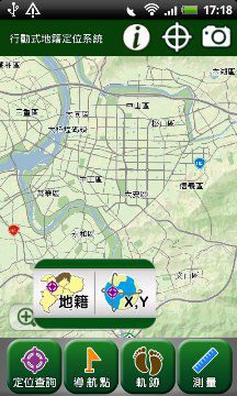
With Mobile Cadastral GIS 3.0 that considerably enhances the interface, map display function, and query speed, users can define the data source and cadastral information to meet their needs. Besides the cadastral query function, the records of waypoint and GPS track provide field surveyors with real-time information. Moreover, field surveyors can check these data as the track reference and analyze them in a desktop computer. 

There are four main features of Mobile Cadastral GIS 3.0. First, it can be widely used with GPS. Second, it can record and manage the information of locations rapidly. Third, it combines with the map measure function. Last, users can find the positions in several ways with this system.

As a result, Mobile Cadastral GIS 3.0 can help surveyors complete their tasks more efficiently. What is more, its user-friendly interface and intuitional manipulation can make the users who have little GIS experience familiar with the system shortly. Mobile Cadastral GIS 3.0 (Android version) is currently available in Taiwan. For more information about Mobile Cadastral GIS 3.0 (Android version), visit
www.supergeotek.com, or contact [email protected]