Asian Surveying & Mapping
Breaking News
Safran, SatSure partner to develop geospatial intelligence solutions for India
French aerospace giant Safran Electronics & Defense and Indian...
Singapore unveils road map to help develop international business standards and conformance
Singapore has unveiled plans to help develop international standards...
Adelaide University to run space and defence venture launchpad ahead of Australian Space Forum
Adelaide University’s Innovation & Collaboration Centre (ICC) will deliver...
Japan’s H3 rocket returns to space with successful launch after December setback
Japan’s flagship H3 rocket has returned to flight six...
KONGSBERG accelerates seabed mapping developments with Ocean Exploration Trust expedition aboard Exploration Vessel Nautilus
KONGSBERG and the Ocean Exploration Trust (OET) are set...
Russian satellites linked to mysterious GPS disruptions across several countries
Since 2019, GPS signals across Europe, Greenland and Canada...
Isro’s Bahubali LVM3 that launched Chandrayaan-3 to be handed to private sector
IN-SPACe has invited Indian companies to take over the...
India to host 13th UN Global Geospatial Information Management Asia-Pacific Conference
India is hosting the 13th United Nations Global Geospatial...
Unseenlabs’ BRO-22 to Become the First Foreign Private Satellite Launched Aboard Japan’s H3 Launch Vehicle
Scheduled for June 10, between 09:53 and 11:52 a.m....
PLD Space increases investment in its Launch Complex at the Guiana Space Centre (CSG) to €35M, strengthening Europe’s sovereign space infrastructure
The investment is expected to generate approximately €21 million...

June 21st, 2011
SuperGeo Officially Releases SuperGIS Mobile Tour 3.0 Android Version

SMT

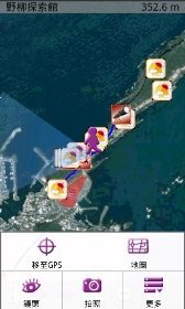
In addition to clear and intuitive interface, SuperGIS Mobile Tour 3.0 offers diverse media including text, images, video and audio for travel guide, making users browse and access vivid information of scenic spots, local hosts and websites with much ease. What’s more, its GPS navigation function can assure tourists of correct and safe routes by reminding tourists that they are approaching the dangerous area or deviating from the route. 

Another feature of SuperGIS Mobile Tour 3.0 is the simple installation process. Users can save map data and configuration file into a SD card or transmit data with a USB cable. Afterwards, the data can be installed in the handheld devices supporting .NET CF 2.0 SP2 or above. Moreover, SuperGIS Mobile Tour is integrated with GPS, GIS, AR (Augmented Reality) technologies, allowing users to intuitively tap the information on the panel.  

With rich tour information and comprehensive support functions of SuperGIS Mobile Tour 3.0, tourists are able to design and manage their journeys in a user-friendly manipulation environment.  

For more information of SuperGIS Mobile Tour 3.0, please visit www.supergeotek.com