This morning at our Explore 2021 user conference, we announced two major new products: Pelican, a next-generation fleet of satellites for very high resolution imagery that will begin launching next year and be operational in 2023, and Fusion with SAR, a cutting-edge data enhancement to our existing Fusion Monitoring product.
When fully operational, the Pelican constellation replenishes and upgrades Planet’s existing high resolution SkySat fleet with better resolution, more frequent image revisit times, and reduced reaction time and latency. The Fusion line will now include SAR (synthetic aperture radar) data, enabling customers to see through clouds with a data stream of continuous landscape monitoring.
Pelican
With increased response times, Pelican customers will be able to task and receive images with significantly reduced latency. The constellation will offer enhanced image resolution, enabling customers to see fine details like road markings. When fully operational, the Pelican fleet will exceed SkySat’s market-leading global intraday revisit frequency of up to 10 times. When paired with Planet’s full suite of daily, global monitoring data and analytics solutions, Pelican will enable powerful new insights that drive unparalleled awareness and decision making for our users working in government, sustainability, finance, insurance, and more. The Pelican constellation was designed in-house and will be built at our headquarters in San Francisco.
“Pelican significantly advances Planet’s product suite with the highest temporal resolution and revisit times that we have ever offered, while dramatically reducing the time between tasking and receipt of an image. In a world that is increasingly fast-changing and unpredictable, this kind of detailed information on demand will be a game changer for our customers who every day need to make quick, consequential decisions,” said Planet’s Senior Vice President of Space Systems James Mason.
Our agile and modular approach towards designing and building spacecraft and software enables us to quickly innovate our products, providing timely, detailed, and unique datasets to customers every year. In this vein, the Pelican satellite architecture leverages that of the Carbon Mapper constellation, which was announced in April 2021. This modularity and multi-mission flexibility is a defining characteristic of our agile aerospace methodology and enables the company to pursue two critical and ambitious missions quickly and affordably.
Fusion with SAR
Last year at Explore 2020, we announced Fusion Monitoring, a unique solution that combines Planet’s daily, global PlanetScope monitoring data with additional datasets to deliver a consistent stream of information about a customer’s area of interest. This year, we will now merge SAR data from Sentinel 1 into the Fusion line, providing improved sensing to customers in the agricultural sector. This additional data stream will help to boost the reliability of agronomic models that consume Fusion data, especially in very cloudy regions. SAR data has the advantage of imaging through clouds and weather that obscure optical data. By incorporating SAR data into the Fusion product, Planet can offer superior continuous monitoring of crop health and capture key events like harvesting or the effects of storm damage.
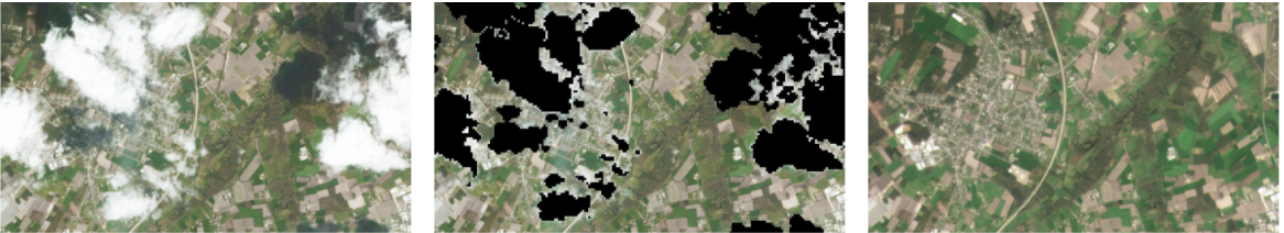
SAR enabling advanced imaging of areas previously obscured by cloud cover over Eksel, Belgium © 2021, Planet Labs Inc. All Rights Reserved.
“All of Planet’s data is analytics ready. This is the foundation of our Fusion product line and core to our ability to combine Planet data with that of other sensors,” said Planet President Kevin Weil. “By incorporating SAR into our daily Fusion monitoring product we ensure direct measurements regardless of cloud cover, providing more insights to our customers to reliably power their decisions.”
Earlier this year, we entered into a definitive merger agreement with dMY Technology Group, Inc. IV (NYSE:DMYQ), a special purpose acquisition company, to become a publicly-traded company.
