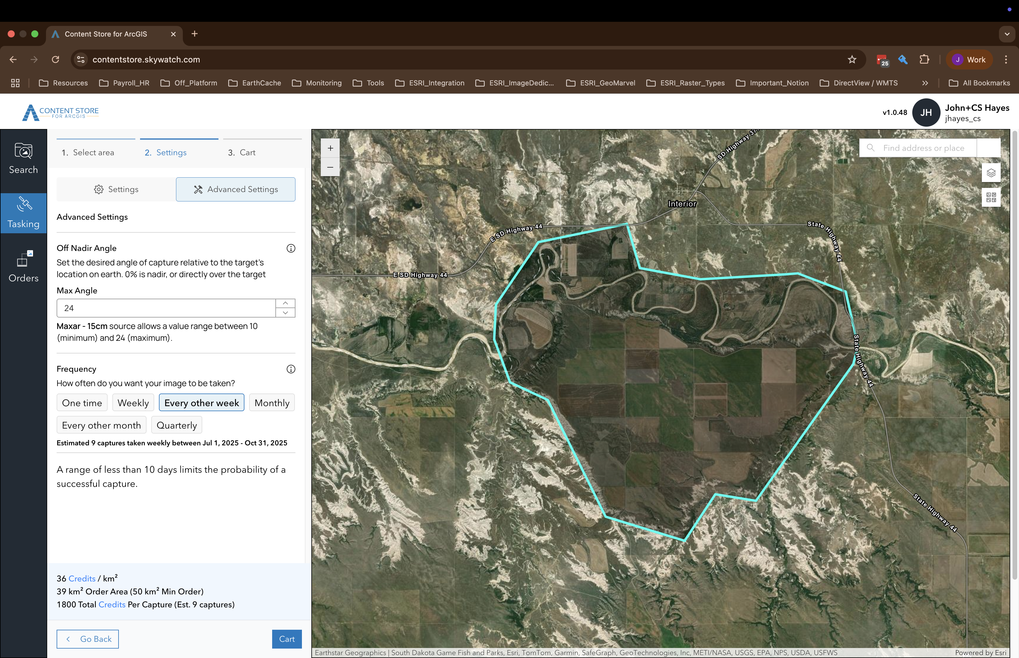
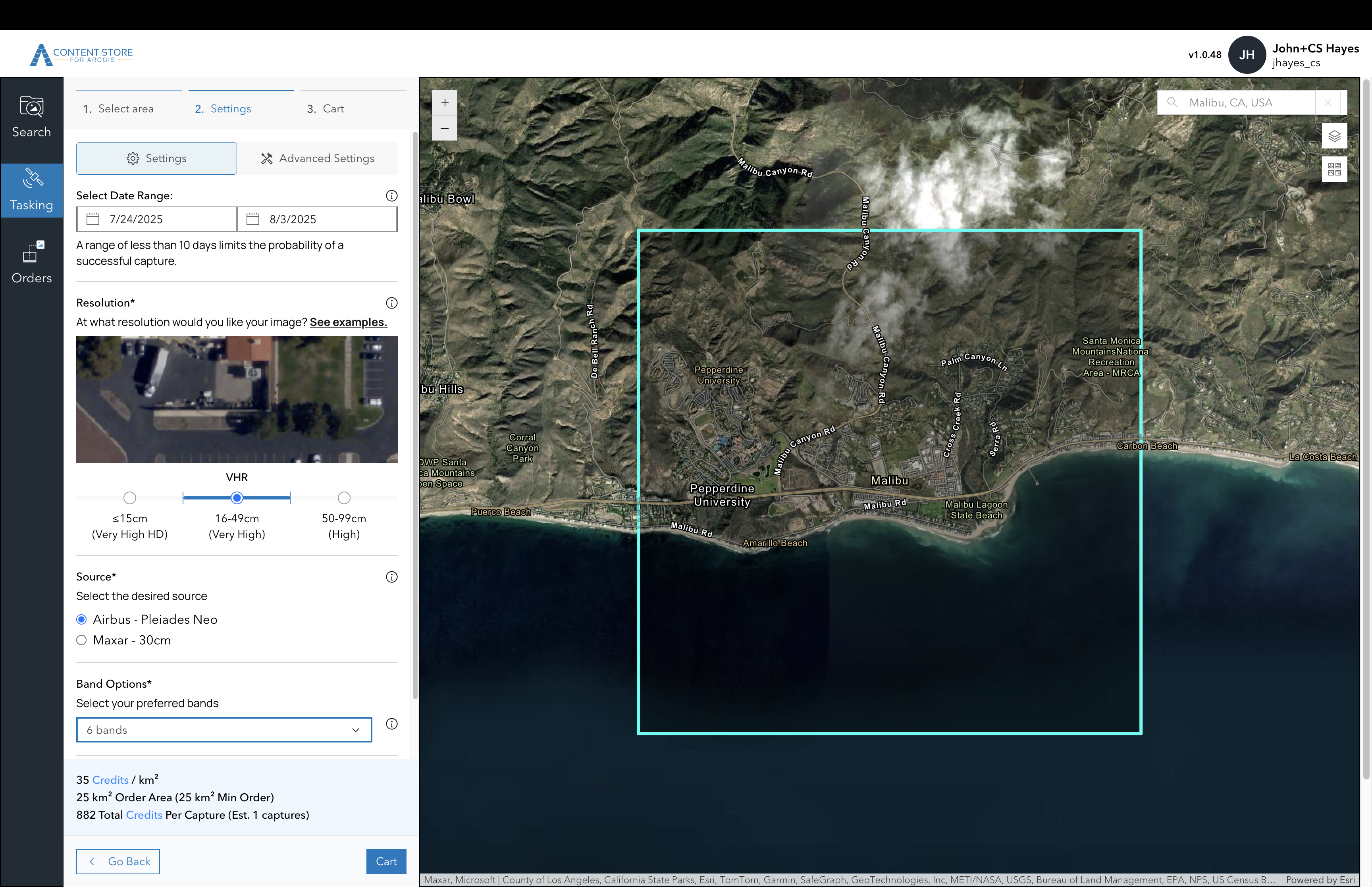
Order the imagery you need with satellite tasking in Content Store for ArcGIS
Satellite tasking, which is the ability to request imagery from a satellite imagery provider for a specific time and place, is now available as part of your ArcGIS workflow through Content Store for ArcGIS. Whether you’re monitoring environmental changes, assessing infrastructure impacts, or planning urban development, having access to the right imagery at the right time can make all the difference. Now, you can get the exact imagery you need, when you need it, seamlessly integrated into your ArcGIS workflow.
Access to Imagery in ArcGIS
Imagery is a rich source of data in GIS, providing detailed information about the Earth’s surface, including land cover, land use, and other spatial features. By analyzing imagery, GIS professionals can gain insights into the spatial relationships between different features and make more informed decisions. The integration of imagery into GIS analysis enhances the accuracy and depth of spatial understanding. One of the key types of imagery used in GIS is satellite imagery, which supports a broad range of applications.
ArcGIS provides easy access to a wide range of satellite imagery from various sources, including satellite imagery that is included with ArcGIS licenses, satellite imagery from Esri partners, and premium satellite imagery from commercial vendors. This gives you the flexibility to choose the imagery that best fits your project’s needs, whether you require a basic basemap or more specialized data set for in-depth analysis. As a result, you have access to extensive imagery archives that can support a variety of applications.
These archives are incredibly useful for a wide range of projects, providing a wealth of both historical and very recent imagery that can offer valuable information However, for some projects, especially those focused on areas that are remote, or cases where snapshots of a particular area of interest is needed on a regular basis, it can be challenging to access the imagery you need in the timeframe you need it.
Customized and Timely Imagery with Tasking in Content Store for ArcGIS
Fortunately, ArcGIS provides a solution to the challenge of obtaining up-to-date and specific satellite imagery. With the release of Content Store for ArcGIS in Q1 2025, you gained access to a single platform for high-quality, ready-to-use satellite imagery from multiple leading providers. This app simplifies the process of adding commercial imagery to GIS projects by enabling you to quickly discover, purchase, and use imagery from within ArcGIS. As a result, the data procurement managers in your organization can now benefit from streamlined purchasing processes, and end-users can accelerate their access to the imagery needed to optimize their projects.
The Q2 2025 ArcGIS Online update introduced a significant enhancement to Content Store for ArcGIS. Now, in addition to providing the ability to access an extensive archive library of pre-captured imagery from providers like Maxar, Airbus, and Planet, you can also place orders for fresh imagery of specific area – a process called satellite tasking.
The capability allows you to specify the exact area, capture frequency, and resolution required for their projects. Higher resolution images are ideal for detailed analysis, while lower resolution images are better suited for broader overviews. After reviewing specifications, you can select from a list of providers that meet your requirements and place an order. This ensures that the imagery aligns precisely with your project needs. The delivery time for tasked satellite images varies depending on factors such as satellite orbit, provider capacity, and data processing, typically ranging from a few hours to 48 hours after capture.

Tasking Satellites Complements Archived Imagery
To illustrate the various ways ArcGIS enables you with access to imagery, including the ability to task satellites, consider a real-world scenario where precise and timely imagery is crucial. Imagine you are a GIS Manager who is on a committee to plan a large-scale agricultural project in a remote region. This requires a deep understanding of the site and its surroundings. See how imagery and ArcGIS can support the process!
You are tasked with installing the project, and your first step is to understand what happened in your area of interest over the past 3-5 years. This is important because you need to assess aspects of the site right now, but what has changed. You begin by exploring the ArcGIS Living Atlas of the World, which provides a wealth of data to help you understand the site and what’s around it. Imagery that is immediately available to you includes basemap imagery, multispectral imagery, temporal imagery, and even imagery of specific events that happened in the area. This data is vital to help you assess changes in land use, vegetation health, and environmental conditions, and it provides a solid baseline for project planning. You can now see how the area has evolved, identify trends, and understand the historical context of the site.
Next, you need to add very recent imagery at a higher resolution so you can accurately map the terrain, identify specific soil types, and plan crop layouts. For those tasks, you’ll need very high resolution imagery. You open Content Store for ArcGIS. There, you find imagery from just a few months ago, and it’s higher resolution than the archived imagery you used for your baseline.
Finally, you need imagery that is the most current, and you know you’ll need regular snapshots of the area as the project progresses. For that, you also leverage Content Store for ArcGIS and choose the capability to task a satellite. You choose the resolution you want and the date range, and once the image is captured and ready, it will be delivered to you, ready to use in ArcGIS.

Efficient and Cost Effective
Tasking satellites through Content Store for ArcGIS is not only a powerful way to get the most up-to-date imagery but also an efficient and cost-effective solution. Instead of relying on periodic, pre-scheduled captures that may not align with your project timeline, you can request imagery on-demand. This means you can capture images at the exact moment when they are most useful for your project, such as during the initial site assessment or when making critical installation decisions. The ability to specify the exact area, resolution, and frequency of captures ensures that you only pay for the data you need, reducing unnecessary costs.
Additionally, the streamlined ordering process and quick delivery times minimize the time and resources required to procure and integrate the imagery into your project. For your agricultural project, this means you can quickly and accurately plan the installation of irrigation systems, crop rows, and other infrastructure, ensuring that your project is both feasible and sustainable from the start.

Make Virtually Any Area of Interest Virtually Accessible
One of the most significant advantages of satellite tasking is its ability to capture imagery from remote, hard-to-reach, and dangerous areas without the need for personnel on the ground. This ensures the safety of your team and allows for data collection from locations that would otherwise be inaccessible. The high-resolution images provided by satellites meet the rigorous standards of modern GIS projects, offering exceptional quality. For your agricultural project, this means you can assess the site conditions and environmental impacts without the risks and logistical challenges of ground surveys, particularly in remote regions where access is limited and conditions can be harsh.
Whether you are planning the installation of a new farm, evaluating the suitability of a potential site, or monitoring the progress of your project, satellite tasking through ArcGIS ensures that you have the necessary data to make informed decisions, no matter how remote the location.
Timely, Customized Imagery For Many Use Cases
The addition of satellite tasking to the Content Store for ArcGIS is a practical and useful feature. It provides a seamless and efficient way to obtain the precise imagery needed for any project. This feature ensures that you have the most current and relevant data at your fingertips, all while being cost-effective and safe.
So, whether you are managing a remote agricultural project, conducting environmental monitoring, assessing infrastructure, or handling agricultural management, satellite tasking may be the right choice for your project. It serves as an additional information source tailored to your specific needs, ensuring that your business decisions are more informed or that you can make discoveries with a global impact, regardless of your goal.
Ready to Find Some Imagery?
See What’s Included with Your ArcGIS Online License Agreement
Start browsing the imagery you can access right away from the ArcGIS Living Atlas of the World. Depending on what you want to achieve, whether it’s using imagery for a backdrop or for advanced analysis, you’ll find basemap imagery, multispectral imagery, temporal imagery, and event imagery from authoritative sources.
Purchase Imagery from Library Archives or Task Satellites
For additional imagery needs, you can access Content Store for ArcGIS, a free app that allows you to purchase premium satellite and aerial imagery from leading commercial providers. To get started, contact your ArcGIS Online administrator to request access to Content Store for ArcGIS by clicking on the Get it Now button in the ArcGIS Marketplace listing. They will grant you the necessary permissions based on your user type and permissions.
For more information about Content Store for ArcGIS, read the introductory blog, Enrich Your GIS with Premium Commercial Satellite Imagery.

