Lake Mary, FL, August 5, 2020 – FARO Technologies, Inc. (NASDAQ: FARO), the global leader for 3D Metrology, AEC and Public Safety Analytics, today announced the release of FARO® Trek. Trek is a fully autonomous 3D mobile scanning integration built in collaboration with the Massachusetts-based robotics firm Boston Dynamics. The innovative solution combines the cutting-edge scanning speed and accuracy of the FARO FocusS Laser Scanner with Spot, a quadruped robot capable of remote and autonomous data capture in challenging environments.
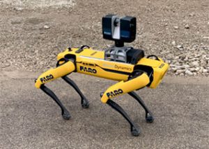
Ideal for general contractors and construction managers to verify production and quality on job sites, Trek leverages Spot’s Autowalk feature to create a repeatable automated scanning workflow. This allows for streamlined data collection and improved efficiency. The information collected is the same each time, ensuring enhanced analysis and reporting. Autowalk automates the inspection process after operators initially program the route walking alongside the robot. Relying on sophisticated sensors, Spot is then able to repeat that same route autonomously, and even makes minor adjustments to complete the job.
“FARO Trek marks an exciting collaboration of two leading technology companies singularly focused on solving the challenges that customers face,” said Rob Miller, FARO’s Director of Business Development. “Progressive building and facility owners are increasingly motivated to support this type of mobility and automation, particularly for their most difficult new construction and renovation projects.”
Spot is designed for remote user operation and autonomous sensing. Using a series of integrated sensors, the robot can understand dynamic environments and avoid obstacles or people. It is through these twin capabilities that the Trek-Spot union excels as the hybrid device seamlessly enables data-rich reality capture via an automated experience. The result is a vast improvement in customers’ time to decision while delivering more data, automated. Future applications will allow the Trek-Spot integration to autonomously capture 3D laser scans in hazardous, confined spaces and low-oxygen environments, otherwise dangerous for humans.
“Reality capture has become more critical to on-schedule project delivery than ever before,” said Brian Ringley, Boston Dynamics’ Construction Technology Manager. “The FARO Trek integration provides customers with the ability to document true as-built conditions of their site in a repeatable fashion. Because this high-frequency point cloud data collection is automatically aligned relative to project control points and BIM coordinate systems, it’s easier than ever to maintain a continuously updated digital twin.”
The FARO FocusS Laser Scanner enables users to capture fast, accurate measurements of complex objects and buildings, with intuitive workflows that foster an enhanced user experience. A built-in 8-mega-pixel HDR camera captures detailed imagery while providing a natural color overlay to the scan data in a range of lighting conditions. Lightweight and compact with a 4.5-hour battery per charge, the FocusS is a complete integrated solution designed for secure and reliable mobile scanning.
For more information about FARO, visit www.faro.com.
Media Contact: Mark Benhard 407.333.9911 x 1269 or [email protected]
