(Livermore, California, USA, 10 March 2020) – AGTEK Development Company, part of Hexagon, announced today the introduction of Materials, the next-generation software to simplify takeoff and production control of construction materials.
AGTEK has introduced Materials, the next-generation software to simplify takeoff and production control of construction materials
The new software puts materials first and accounts for all construction cost items without entering any data twice. Users can easily measure lengths, areas and counts, extending them into yards of concrete, tons of asphalt, lengths of guard rail, counts of catch basins, and any other cost item. Jobs are segmented into trade-specific classes, including storm, sewer, water, electrical, grading, demolition, and phases to track job progress.
Leveraging the power of drone/UAV data
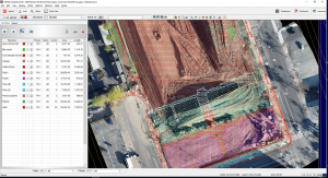
Materials is fully integrated with AGTEK’s Gradework software to harness the power of Drone / UAV data. Existing conditions can be validated and demolition quantities quantified before submitting a bid. Once the job is won, production progress and procurement management for all classes, phases, and type of materials are tracked on site. Progress is visualised using orthomosaic images and share data effortlessly with the field.
Share Materials data with ease
Put material data into the hands of those who need it, in an easy to understand format, ensuring better decisions are made. In the office, visualise and interrogate all materials data in Google Earth to provide real-world experience of the project and its surrounding environment. In the field, data can be exported to AGTEK’s SmartPlan mobile app to access all material quantities on Apple or Android phones or tablets.
AGTEK Development Company – Dirt.Simple.Solutions.
AGTEK, part of Hexagon, provides Dirt Simple Solutions for the construction industry to accurately takeoff and estimate construction quantities, model efficient construction processes and measure progress throughout the construction life cycle.
Hexagon is a global leader in sensor, software and autonomous solutions that are putting data to work to boost efficiency, productivity, and quality across industrial, manufacturing, infrastructure, safety, and mobility applications.
