
WALTHAM, Mass – Excelitas Technologies® Corp., a global technology leader delivering innovative, customized photonic solutions, contributed its Avalanche Photodiode technology to NASA’s GEDI instrument currently orbiting Earth on the International Space Station (ISS). Excelitas wishes to congratulate NASA and the University of Maryland team led by Dr. Ralph Dubayah for the first release of data after all in-flight validation and testing was completed.
GEDI (Global Ecosystem Dynamics Investigation), launched in late 2018, is actively mapping Earth from the ISS on a 2-year mission to provide extremely high-resolution 3D images of forest canopy structure and land elevation. Year-over-year variations in vegetation density and their resulting impact to the carbon cycle are key elements in modeling climate changes and humanity’s impact on our planet.
GEDI models will further enhance data being developed by other Earth-observation missions that are monitoring the evolution of structures on Earth. The contribution of GEDI to enhanced weather forecasting, forest management, glacier and snowpack monitoring, and other applications is expected to be immeasurable. Following validation of structure measured by the NASA LVIS mission, (also emloying Excelitas avalanche photodiodes), the first data sets have been released to the pubic via the Land and Processes Distributed Active Archive Center (LP DAAC), allowing all climate scientists to correlate GEDI data to their own.
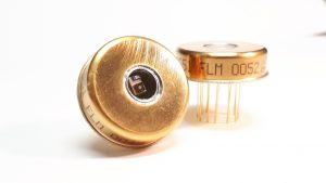
“We’re proud and humbled to have provided custom space-qualified hybrid receivers to NASA for this mission,” said Eric Desfonds, Excelitas Product Line Manager, Defense and Aerospace Sensors. “For several decades, we have been honored to collaborate so closely with the NASA Goddard team as they continue to aim for bold scientific goals. Building upon our modules delivered for several prior missions, Excelitas Canada designed, screened and qualified some of our very best YAG-enhanced APDs to enable reliable detection of the faint signal bounced back from Earth after traveling over 80 km.”
Excelitas’ avalanche photodiode (APD) allows the detection of full-waveform return signals from the ISS. Going beyond a simple distance measurement or 2D imaging, the waveform provides key information on the height and density of vegetation within a sampled footprint. The actual 3D structure of each sampling area is thus recorded and its variation can be studied over time and compared to other field observations.
Excelitas has a long heritage of designing and producing YAG-enhanced APDs used in several space surveying missions. “We look forward to continued collaboration with NASA on other linear LiDAR missions for several more years,” said Desfonds.
Dr. Xiaoli Sun, Research Physical Scientist at the Planetary Geology, Geophysics, and Geochemistry Laboratory, from NASA Goddard Space Flight Center (GSFC) will present Paper 11287-39, titled “Advanced Silicon Avalanche Photodiodes on NASA’s Global Ecosystem Dynamics Investigation (GEDI) Mission”, during Session 9: Sensors and Ruggedized Systems II, at SPIE Photonic West conference on February 6, 2020.
Excelitas Technologies is exhibiting at SPIE Photonics West in the Moscone Center, February 4-6, 2020 (Booth 1149). Attendees are invited to visit Excelitas’ booth to discuss their requirements for optical LiDAR payloads and other mission-critical optoelectronics and advanced electronic systems.
About Excelitas Technologies
Excelitas Technologies® Corp. is a global technology leader focused on delivering innovative, high-performance, market-driven photonic solutions to meet the lighting, optronics, detection and optical technology needs of global customers. Serving a vast array of applications across biomedical, scientific, safety, security, consumer products, semiconductor, industrial manufacturing, defense and aerospace sectors, Excelitas Technologies stands committed to enabling our customers’ success in their end-markets. Excelitas Technologies has 7000 employees across North America, Europe and Asia, serving customers across the world.
Connect with Excelitas on Facebook, LinkedIn and Twitter.
Excelitas® is a registered trademark of Excelitas Technologies Corp. All other products and services are either trademarks or registered trademarks of their respective owners
