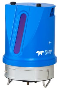
VAUGHAN, Canada — September 17, 2019 — Teledyne Optech, a Teledyne Technologies [NYE:TDY] company and global leader in advanced lidar sensors, will showcase its new high-resolution, long range scanner, the TLS-M3 at InterGEO this week. The new scanner boasts powerful features including a protective encasement for marine environments, integrated inclinometer, and compass with external camera support.
With the capacity to operate at up to three speeds, the TLS-M3 has ranges of 250m up to 2000m and is versatile enough to be used for tripod, platform or vehicle scanning. The wide, adjustable field of view provides up to four returns at 50,000 to 500,000 points per second.
The TLS-M3 can be easily integrated with most commonly used data collection software for immediate ease of use via an included API for unit control, data streaming, post processing and diagnostic feedback.
Designed for marine applications such as port and harbor, coastal and structure survey, TLS-M3 also specializes in real time monitoring for permanent installations and volume computations and land mobile mapping for asset management and clash detection.
Visitors to InterGEO are invited to come and learn more about the TLS-M3 during its exhibit from September 17-19 at the Teledyne Optech Booth in Hall 3, B3.042.

About Teledyne Optech
Teledyne Optech is part of the Teledyne Imaging Group and a world leader in high-accuracy lidar 3D survey systems, integrated cameras, and productivity-enhancing workflows. With operations and staff worldwide, Teledyne Optech offers both standalone and fully integrated lidar and camera solutions for airborne mapping, airborne lidar bathymetry, mobile mapping, terrestrial laser scanning, and mine cavity monitoring, as well as space-proven sensors. Teledyne Optech supports its clients with an around-the-clock team, on-site service, and regular efficiency enhancements to the workflow of its integrated systems