
(HEERBRUGG, SWITZERLAND) – Leica Geosystems, part of Hexagon, today announced Leica Cyclone 3DR, the new reality capture software that fuses technology for centralised, full-scale point cloud management from Leica Cyclone with advanced, automated point cloud analysis and modeling from 3DReshaper. The new software delivers a simplified platform for surveying, architecture, engineering and construction (AEC) and tank inspection applications.
With industry-centric guided workflows, Cyclone 3DR includes a range of adaptable features for automating cleaning, modelling, meshing, extraction, inspection and reporting. An assortment of 3D deliverables can be created to meet the unique needs of reality capture professionals across a wide spectrum of fields. Specialised workflows, such as construction monitoring, tunnelling surveying and tank inspecting (based on the API 650/653 standard) are also available. Cyclone 3DR further connects the use of reality capture into multiple industries through its wide support of data formats, including IFC, STL, OBJ, VRML, DXF, STEP, IGES and more.
“Leica Cyclone 3DR is a huge step forward. The ability to fuse workflows of Cyclone and 3DReshaper presents a step-change in productivity and allows us to leverage the best of the two products to drive greater field-to-finish productivity,” said Sander Schrodor, innovations manager at Ingenieursbureau Coenradie.
The right data at the right time
Based on Leica Jetstream technology that enables the rapid viewing and use of reality capture data, Cyclone 3DR streamlines the process of providing actionable information directly to clients. Cyclone 3DR leverages the combined expertise of 3DReshaper and Cyclone to deliver a revolutionary new solution to simplify data processing, visualisation and delivery of high-quality meshes, reports and more.
“Our aim is to make the day-to-day working life of our customers easier,” said Faheem Khan, Leica Geosystems vice president of survey solutions. “We kept this front of mind in developing Cyclone 3DR. Not only will users, new and old, feel comfortable in the software’s intuitive user interface but we also specifically created familiar application-orientated workflows tailored for the industry and application our customers operate in.”
For more information about the Leica Cyclone 3DR laser scanning software, please visit https://leica-geosystems.com/products/laser-scanners/software/leica-cyclone/leica-cyclone-3dr
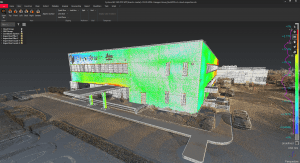
The new Leica Cyclone 3DR laser enables rapid validation of design and construction activities through the integration of Leica JetStream technology and BIM model support.
Leica Geosystems – when it has to be right
Revolutionising the world of measurement and survey for nearly 200 years, Leica Geosystems, part of Hexagon, creates complete solutions for professionals across the planet. Known for premium products and innovative solution development, professionals in a diverse mix of industries, such as aerospace and defence, safety and security, construction, and manufacturing, trust Leica Geosystems for all their geospatial needs. With precise and accurate instruments, sophisticated software, and trusted services, Leica Geosystems delivers value every day to those shaping the future of our world.
Hexagon is a global leader in sensor, software and autonomous solutions. We are putting data to work to boost efficiency, productivity, and quality across industrial, manufacturing, infrastructure, safety, and mobility applications.
Our technologies are shaping urban and production ecosystems to become increasingly connected and autonomous — ensuring a scalable, sustainable future.
Hexagon (Nasdaq Stockholm: HEXA B) has approximately 20,000 employees in 50 countries and net sales of approximately 3.8bn EUR. Learn more at hexagon.com and follow us @HexagonAB.
