Asian Surveying & Mapping
Breaking News
bitsensing Signs MOU with IKIO Technologies to Advance AI-Based Traffic Monitoring on India’s Expressways, Highways and Municipal Areas
Backed by proven success in South Korea and Europe,...
Nuri rocket successfully completes KAIST’s next-gen satellite mission
The Korea Advanced Institute of Science and Technology (KAIST)...
President Lai reviews progress on first indigenous satellite constellation
President Lai Ching-te said developing space technology is a...
Japan’s iQPS lines up eight SAR launches
ST. LOUIS — Japan’s Institute for Q-shu Pioneers of...
UAE Astronauts Promote AI and Collaboration in Space at GITEX Europe
The Arab world’s first astronaut, Hazzaa Al Mansouri, and...
New species of space-adapted bacteria discovered on China’s Tiangong space station
Scientists have discovered a previously unknown strain of microbe...
Isro’s 101st mission fails as PSLV-C61 suffers third-stage anomaly
India’s latest Earth observation satellite mission faced a setback...
Iraq’s First Fully Solar-Powered Village in Kulak Is Now Operational
ERBIL, Kurdistan Region – May 20, 2025 — The...
Australia’s Gilmour Space Technologies ready to launch maiden Eris Test flight the nation’s first orbital launch in over 50 years
Gilmour Space Technologies is the leading launch services company...
Korea’s space agency seeks revision of plan to modify next-gen rockets into reusable system
South Korea's aerospace agency said on Thursday that it...

The GNSS-Reflectometry (GNSS-R) instrument on the EOS-08 satellite commenced operations on Aug. 18, 2024. The raw data is being processed at the National Remote Sensing Centre (NRSC-ISRO) in Shadnagar, Hyderabad, using algorithms and data processing software developed by the Space Applications Centre (SAC-ISRO), Ahmedabad. Multiple levels of data products have been successfully generated. 

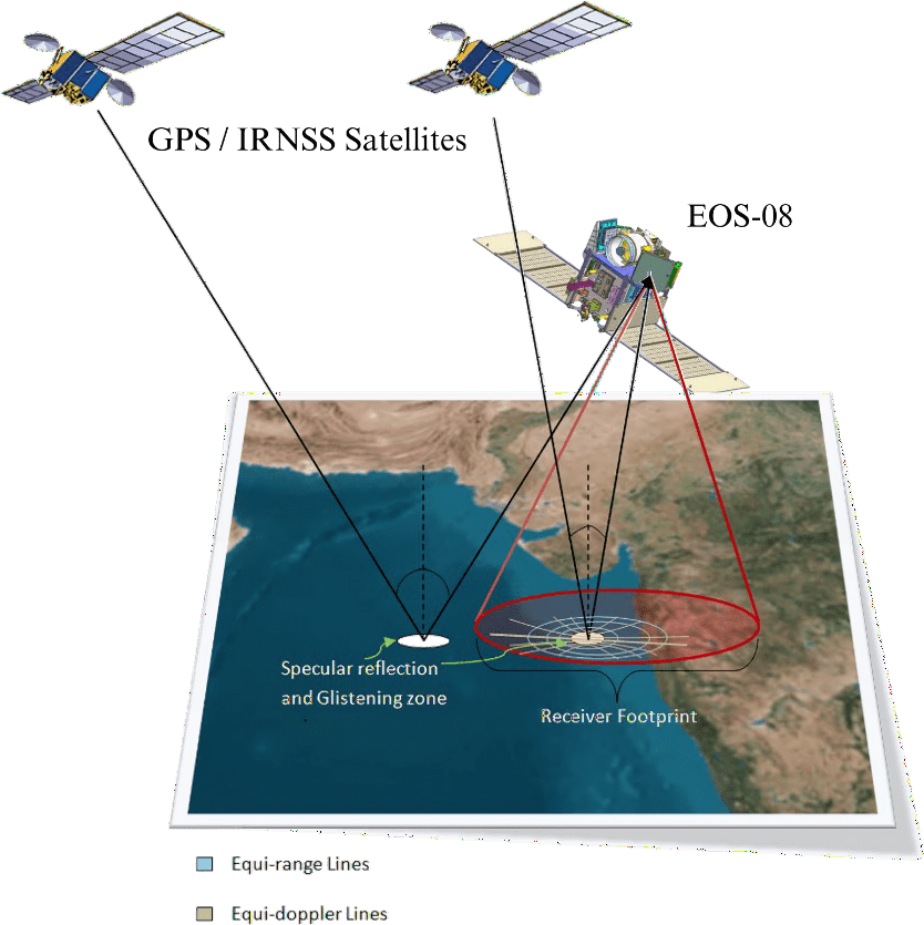
GNSS-Reflectometry represents a new mode of remote sensing. Signals from Global and Regional Navigation Satellite Systems (GNSS/RNSS), such as GPS and NavIC, are reflected off various Earth surfaces, including oceans, agricultural lands and river bodies. These reflected signals are collected by a precision receiver onboard the satellite (see accompanying figure) as it orbits the Earth at an altitude of 475 kilometers. This measurement system operates without dedicated transmitters and is shallow in resource consumption—requiring minimal size, weight and power. Additionally, it can scale up as a constellation of receivers for faster coverage, making this innovative remote-sensing mode highly useful. 

Image Credit: ISRO