Asian Surveying & Mapping
Breaking News
China unveils first homegrown space mining robot
China's first space mining robot has been developed by...
North Korea rejects G7 call for denuclearization, vows to ‘strengthen’ nuclear forces
North Korea on Monday vowed to "steadily update and...
Taiwan showcases innovative technologies at Satellite 2025
Innovative technologies are on display at the Taiwan Space...
Japanese Astronaut Onishi departs with three others for 2nd Space Mission
Takuya Onishi has left for space for his second...
Saudi Arabia, Korea Sign Memorandum of Cooperation to Enhance Space Collaboration
Riyadh, SPA: The Saudi Space Agency (SSA) today signed...
UAE, Bahrain boost space and climate monitoring with satellite launches
The UAE and Bahrain successfully launched on Sunday their satellites, Etihad-SAT and...
UAE launches first SAR satellite Etihad-SAT
The satellite, weighing 220kg, was launched into space aboard...
China opens 2028 Mars sample return mission to international cooperation
HELSINKI — China is inviting interested parties to submit...
ISRO Chairman Inaugurates Research Centre At IIT Madras To Address Thermal Challenges In Space Applications
This will be nodal centre for research in heat...
Chandrayaan-5 Mission Approved, To Carry 250 kg Rover: ISRO Chief
The Chandrayaan programme has been instrumental in India's lunar...
One of the images of the target space debris taken during the “fixed-point observation” (H-IIA upper stage, which launched Greenhouse Gases Observing Satellite (GOSAT), also known as Ibuki in 2009). 

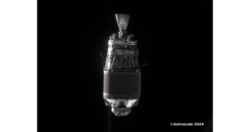
The Japan Aerospace Exploration Agency (JAXA) advanced the Commercial Removal of Debris Demonstration (CRD2) Phase I project, under which the demonstration satellite Astroscale’s ADRAS-J successfully captured images of space debris, a non-cooperative target, through “fixed-point observation.” These images have been released by Astroscale Japan Inc. 

The “fixed-point observation service” is one of four services that JAXA requires for Phase I of CRD2. This service involves observing the target debris from a fixed point in the target’s orbital coordinate system and providing continuous images of the target with the required image quality and data volume.