Asian Surveying & Mapping
Breaking News
Launch of Australia’s 1st orbital rocket, Gilmour Space’s Eris-1, delayed again
Update for 6:15 p.m. ET on July 1: Gilmour Space...
SAASST, UAE Space Agency strengthen scientific partnership
SHARJAH- Prof. Hamid M.K. Al Naimiy, Director of the...
Shubhanshu Shukla to speak to students and ISRO scientists this Friday
Indian astronaut Shubhanshu Shukla will interact with school students...
ISRO hands over 10 advanced technologies to Indian firms in major push for space commercialisation
The Indian Space Research Organisation (ISRO) has transferred ten...
DIGIPIN Launched: India Embraces Geospatial Precision in Digital Addressing
IIT Hyderabad (IITH), in partnership with the Department of...
HAL to build, market Isro’s SSLV in landmark deal
New Delhi, Jun 20: In a historic move for...
Taiwan developing space capabilities for all-weather imaging
TAIPEI (TVBS News) — Taiwan is advancing its space...
Honda hails successful test of reusable rocket as it looks to get into the space business
Tokyo — Japan's second-biggest carmaker, Honda, has successfully tested...
China’s space program provides larger platform for broader international cooperation
BEIJING -- Experts from China's manned space program said...
India To Launch $1.5 Billion Joint Earth Mission With NASA In July
National Aeronautics and Space Administration (NASA) and the Indian...

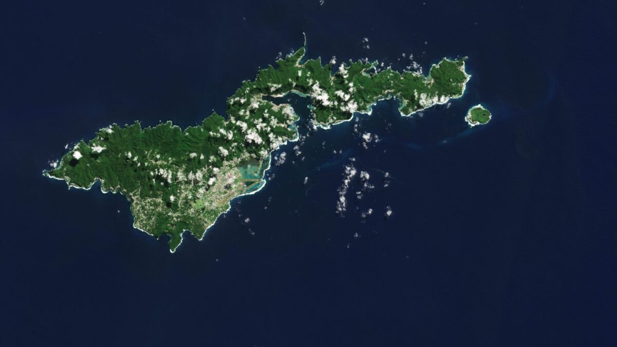
The Copernicus Sentinel-2 mission captured an amazing view of the tropical island of Tutuila, the largest in the American Samoa archipelago in the South Pacific Ocean. 

American Samoa is an unincorporated territory of the United States and is part of the Samoan Islands chain, situated some 4,000 kilometers southwest of Hawaii and about 3,000 kilometers northeast of New Zealand. The eastern part of the chain of islands forms the American Samoa, while the western part forms the independent state of Samoa. 

American Samoa comprises five volcanic islands: Tutuila, Aunu’u, Tau, Ofu and Olosega; and two coral atolls, Rose and Swains. 

Tutuila is a small, narrow island and home to many volcanic mountains. At 653 meters, Mount Matafao, which lies in the centre of the island, is the highest. The mountain range, which cuts across the island, is rugged with steep cliffs dominating the northern part of the island. The south is flatter.  Coral reefs create barriers to the open sea, resulting in lagoons, visible in turquoise, prominent off the southern coast.  

Image Credit: Contains modified Copernicus Sentinel data (2023), processed by ESA