Asian Surveying & Mapping
Breaking News
Japan Eyes Sovereign D2D Satellite Network
Japan plans to select a proposal this month for...
China schedules Long March 10B rocket launch and recovery attempt
HELSINKI — China is set for a debut flight...
BRICS space agencies meet begins in Bengaluru
Heads and senior representatives of the space agencies of...
“India’s growing space ecosystem to drive global collaboration”, says ISRO Chairman V Narayanan after BRICS Space Agencies Meeting
"India's growing space ecosystem to drive global collaboration", says...
UAE aims to see Emirati on Moon in next 10 years, says MBRSC chief
UAE expects to have a presence on the Moon within...
Safran, SatSure partner to develop geospatial intelligence solutions for India
French aerospace giant Safran Electronics & Defense and Indian...
Singapore unveils road map to help develop international business standards and conformance
Singapore has unveiled plans to help develop international standards...
Adelaide University to run space and defence venture launchpad ahead of Australian Space Forum
Adelaide University’s Innovation & Collaboration Centre (ICC) will deliver...
Japan’s H3 rocket returns to space with successful launch after December setback
Japan’s flagship H3 rocket has returned to flight six...
KONGSBERG accelerates seabed mapping developments with Ocean Exploration Trust expedition aboard Exploration Vessel Nautilus
KONGSBERG and the Ocean Exploration Trust (OET) are set...

July 31st, 2023
Nighttime in Antalya, Türkiye 

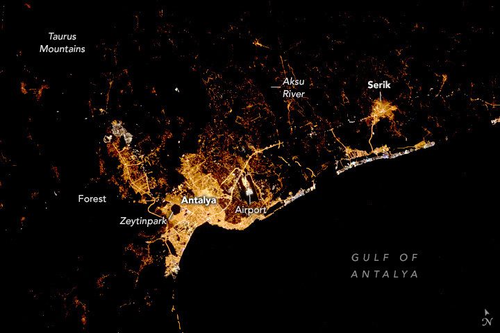
An astronaut aboard the International Space Station took this nighttime photograph of the coastal Mediterranean city of Antalya, Türkiye, in Asia. Located on the southern coast of Türkiye, Antalya is the largest city in this view. The image contrasts brightly lit urban infrastructure against unilluminated parks and natural areas, such as the pentagonal Zeytinpark and surrounding mountain forests. Human-made structures identifiable by lighting patterns include an airport, highways, roads and shipping ports. 

The Taurus Mountains border Antalya to the north and northwest, recognizable in this image as extensive dark areas with small settlements speckled throughout. Agriculture along the Aksu River accounts for the dark space between Antalya and Serik. The Aksu River flows out of the Taurus Mountains, providing water to the community and for irrigating horticulture crops, including tomatoes, peppers and cucumbers. 

Bright lights in white, blue-green and purple hues line the coast between Antalya and Serik. These lights are associated with popular tourist locations like resorts and beaches. White and blue hues often contrast with yellow tones in older cities as bright LED (light-emitting diode) lights replace warm-hued, high-pressure sodium lighting.  

Image Credit: SS Crew Earth Observations Facility and the Earth Science and Remote Sensing Unit, Johnson Space Center