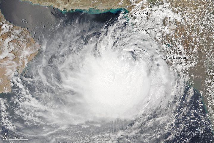
After stirring in the Arabian Sea for more than a week, Cyclone Biparjoy neared the coastline of western India and southern Pakistan in June 2023. The Visible Infrared Imaging Radiometer Suite (VIIRS) on the NOAA-20 satellite acquired this natural-color image of the storm on June 14, 2023, a day before it was forecast to make landfall.
The long-lived cyclone had wind speeds of 129 kilometers (80 miles) per hour on June 14, making it a category 1 storm on the Saffir-Simpson Wind Scale. The storm had spent eight days in the Arabian Sea, generally moving slowly north, until it took a turn to the east on June 14.
Biparjoy was forecast to make landfall on June 15 as a “very severe cyclonic storm” with a sustained wind speed of 125 to 135 kilometers per hour, impacting India’s western state of Gujarat and the densely populated city of Karachi in Pakistan. In preparation for landfall, more than 30,000 people and 200,000 animals had reportedly been evacuated to higher ground.
Strong winds, rain and high tides from the cyclone have already lashed several regions in western India. Multiple deaths have been reported, including drownings off the coast of Mumbai.
Unusually warm waters helped fuel Biparjoy’s rapid intensification twice in its lifetime. Between June 6 and 7, Biparjoy’s wind speed increased from 55 to 139 kilometers per hour (34 to 86 miles per hour), according to the Joint Typhoon Warning Center. The cyclone intensified again between June 9 and 10, when its wind speed increased from 120 to 196 kilometers per hour (75 to 122 miles per hour), making it a category 3 storm.
Image Credit: NASA Earth Observatory image by Lauren Dauphin, using VIIRS data from NASA EOSDIS LANCE, GIBS/Worldview and the Joint Polar Satellite System.
