Asian Surveying & Mapping
Breaking News
The inaugural Earth Observation Forum in Singapore focuses on addressing the regional challenges of securing a climate resilient future
London & Singapore – The inaugural APAC Earth Observation...
ISRO to resume SpaDeX experiments from March 15
The SpaDeX mission was launched on Dec 30 last...
Rocket Lab’s Ambitious Leap and Australia’s Bold Launch: A New Era of Space Exploration Begins
On the forefront of cosmic ambition, Rocket Lab makes...
UAE’s Etihad-SAT satellite set for March 2025 launch
Dubai: The Etihad-SAT project, an advanced Synthetic Aperture Radar...
Astroscale Wins Responsive Space Deal for Japanese MoD
Astroscale has made a breakthrough in the security and defense...
China to send Pakistani astronaut as first foreign guest to its space station
Beijing/Islamabad, China plans to send an astronaut from its...
ISRO’s space launch foray
Next month, the Indian Space Research Organisation (ISRO) will...
News Dubai Loop: A new underground project will change travel in Dubai
Say goodbye to sitting in Sheikh Zayed Road traffic:...
PM Modi Says ISRO, NASA’s Satellite Will Soon Fly Into Space
During his recent visit to the United States, Prime...
China wants Bangladesh to rewrite geography, alter India’s map
China is back at it again. According to reports,...

Storms stronger than Tropical Storm Nalgae lashed the Philippines in 2022, but the extreme rainfall unleashed by Nalgae in late October 2022 spurred landslides and flooding, making it among the season’s deadliest and most destructive storms to hit the island nation.

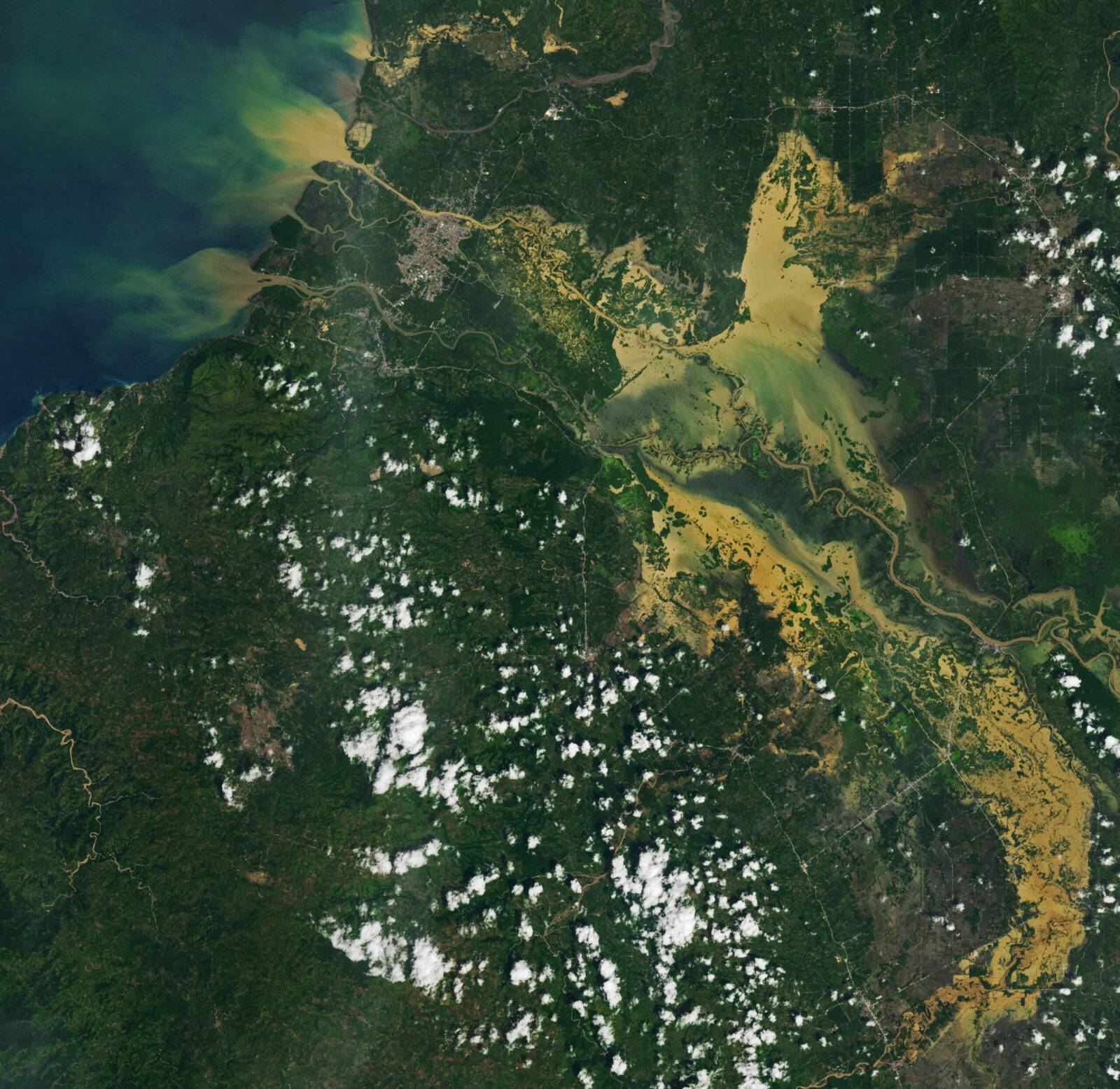
Tropical Storm Nalgae (locally called Paeng) struck the Philippines on Oct. 29, 2022. The storm’s center tracked across the northern part of the country, but wide rain bands swamped areas to the south, including the hard-hit Maguindanao del Norte and Maguindanao del Sur provinces.

Flooding in Maguindanao del Norte is visible in this image acquired on Oct. 30, 2022, with the Operational Land Imager-2 (OLI-2) on Landsat 9. Floodwaters swamped Cotabato City and several nearby towns. Notice the dark-brown floodwater visible in Upi and areas south. Wet, marshy areas were present along the rivers even before the storm. But after the storm, the water became discolored by sediment stirred up by rain and floods. Plumes of this sediment-laden water dispersed into Moro Gulf.

Image Credit: NASA Earth Observatory images by Lauren Dauphin, using Landsat data from the U.S. Geological Survey