Asian Surveying & Mapping
Breaking News
Japan Eyes Sovereign D2D Satellite Network
Japan plans to select a proposal this month for...
China schedules Long March 10B rocket launch and recovery attempt
HELSINKI — China is set for a debut flight...
BRICS space agencies meet begins in Bengaluru
Heads and senior representatives of the space agencies of...
“India’s growing space ecosystem to drive global collaboration”, says ISRO Chairman V Narayanan after BRICS Space Agencies Meeting
"India's growing space ecosystem to drive global collaboration", says...
UAE aims to see Emirati on Moon in next 10 years, says MBRSC chief
UAE expects to have a presence on the Moon within...
Safran, SatSure partner to develop geospatial intelligence solutions for India
French aerospace giant Safran Electronics & Defense and Indian...
Singapore unveils road map to help develop international business standards and conformance
Singapore has unveiled plans to help develop international standards...
Adelaide University to run space and defence venture launchpad ahead of Australian Space Forum
Adelaide University’s Innovation & Collaboration Centre (ICC) will deliver...
Japan’s H3 rocket returns to space with successful launch after December setback
Japan’s flagship H3 rocket has returned to flight six...
KONGSBERG accelerates seabed mapping developments with Ocean Exploration Trust expedition aboard Exploration Vessel Nautilus
KONGSBERG and the Ocean Exploration Trust (OET) are set...

August 26th, 2022
Tracking Marine Plastic Drift from Space

In a hi-tech version of throwing out messages in bottles, prototype trackable buoys were deployed in the waters off Indonesia, whose myriad islands result in some of the most complex, unpredictable currents on Earth.

Made from wood for maximum sustainability, the buoys were developed by French organization Collecte Localization Satellites (CLS). A subsidiary of French space agency CNES, CLS is best known for overseeing the satellite-based tracking of tagged marine animals, buoys and fishing fleets using its long-running Argos geopositioning system, which performs satellite navigation fixes and returns them to CLS via satellite link.

CLS made use of previous experience of marine plastic litter in Indonesia for the buoy deployments. It has previously teamed up with the Indonesian Ministry of Marine Affairs and Fisheries to help guide waste collection efforts—the country’s national marine pollution plan pledges to reduce plastic waste by 70 percent by the end of 2025.

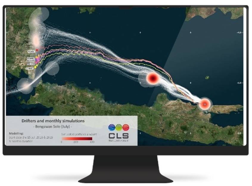
Together with the tracking buoys, the MARLISAT project also involves harnessing Earth observation imagery to detect plastic sources and forecast marine plastic litter’s motion and areas of accumulation using an existing CLS ocean drift model called MOBIDRIFT.

Image Credit: CLS