Asian Surveying & Mapping
Breaking News
Neo Space Group Completes Acquisition of UP42 from Airbus Defence and Space
Neo Space Group (NSG) has officially finalized its acquisition...
Launch of Australia’s 1st orbital rocket, Gilmour Space’s Eris-1, delayed again
Update for 6:15 p.m. ET on July 1: Gilmour Space...
SAASST, UAE Space Agency strengthen scientific partnership
SHARJAH- Prof. Hamid M.K. Al Naimiy, Director of the...
Shubhanshu Shukla to speak to students and ISRO scientists this Friday
Indian astronaut Shubhanshu Shukla will interact with school students...
ISRO hands over 10 advanced technologies to Indian firms in major push for space commercialisation
The Indian Space Research Organisation (ISRO) has transferred ten...
DIGIPIN Launched: India Embraces Geospatial Precision in Digital Addressing
IIT Hyderabad (IITH), in partnership with the Department of...
HAL to build, market Isro’s SSLV in landmark deal
New Delhi, Jun 20: In a historic move for...
Taiwan developing space capabilities for all-weather imaging
TAIPEI (TVBS News) — Taiwan is advancing its space...
Honda hails successful test of reusable rocket as it looks to get into the space business
Tokyo — Japan's second-biggest carmaker, Honda, has successfully tested...
China’s space program provides larger platform for broader international cooperation
BEIJING -- Experts from China's manned space program said...

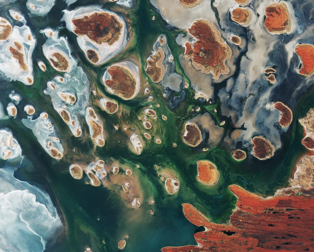
Brown hills speckle the eastern part of Australia’s Lake MacKay in this image from the Copernicus Sentinel-2B satellite. The lake lies at the edge of the Great Sandy Desert, which covers nearly 285,000 square kilometers.

Located on the border of the states of Western Australia and Northern Territory, the salt lake only sees water after seasonal rainfall—if at all. It’s classified as an ephemeral lake, meaning it exists only after precipitation. This is not the same as a seasonal lake, which sees water for longer periods.

About half of Australia’s rivers drain inland and often end in ephemeral salt lakes.

The greens and blues in this image show desert vegetation or algae, soil moisture and minerals—mainly salt. On some of the brown “islands” and on the shore in the lower right, east-west sand ridges forming lines in the landscape can be seen.


Photo Credit: contains modified Copernicus Sentinel data (2017), processed by ESA