Asian Surveying & Mapping
Breaking News
Thailand to launch its second Earth satellite next week
Thailand is set to launch it second Earth observation...
Chinese launch startup’s rocket fails during satellite launch
The Chinese launch company Galactic Energy suffered its first...
First Hong Kong-made satellite set to launch in November from Guangdong province, company reveals
The first Hong Kong-made satellite is set to be...
China launches Yaogan 39 remote sensing satellite
China launched a Long March 2D carrier rocket on...
Saudi Arabia publishes maps with new names for ceded islands
A new map published by Saudi Arabia’s General Authority...
US, Saudi Arabia conclude region’s largest-ever counter-UAS exercise
The US and Saudi Arabia conducted the largest-ever counter-UAS exercise...
Study improves accuracy of planted forest locations in East Asia
An international team led by Purdue University scientists has...
Iran, Russia Working On Joint Research Spacecraft
In an interview with Tasnim, the president of the...
France, Bangladesh sign deal to provide loans, satellite technology during Macron’s visit to Dhaka
French President Emmanuel Macron witnessed the signature of a...
Iran, Russia Working on Joint Research Spacecraft
TEHRAN (Tasnim) – Top universities from Iran and Russia...

The Indian Space Research Organization (ISRO) North Eastern Space Applications Centre (NE-SAC) is using unmanned aerial system (UAS), or drone, technology for large-scale mapping and real-time assessment and monitoring activities for various applications.

NE-SAC designed and assembled several UASs, including a hex copter that can carry up to 2.5 kilograms of different sensors such as thermal, multispectral, optical, hyperspectral and LiDAR. The centre also has a ready-to-fly quad copter with an integrated optical sensor, which can capture high-resolution geotagged aerial photos and high-definition videos, and NE-SAC recently added a fixed-wing UAS.
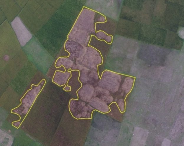
Naramari village of Morigaon District, Assam, India, reported severe infestation of Boro Paddy by the Brown Plant Hopper insect. A 15-minute NE-SAC UAS flight was conducted in the affected area, collecting 0.55 square kilometers of data.

Naramari village of Morigaon District, Assam, India, reported severe infestation of Boro Paddy by the Brown Plant Hopper insect. A 15-minute NE-SAC UAS flight was conducted in the affected area, collecting 0.55 square kilometers of data.