Wednesday, October 30th, 2019
RESTON, Va.- The National Geospatial-Intelligence Agency has awarded the $68 million Zeus contract to Science Applications International Corp. (NYSE: SAIC). The Zeus acquisition is the follow-on contract for the Innovative GEOINT Application Provider Program (IGAPP) that SAIC...
Wednesday, October 30th, 2019
Skipton, UK : Providing the ever-increasing services demanded by a growing population cannot be achieved using existing UK infrastructure, warned Gaist Head of Business Development Ian Job today. “There are over 800,000km of sewer and water supply...
Wednesday, October 30th, 2019
Chicago, IL – HERE Technologies, a global leader in location platform services, today celebrated its 20-year anniversary with Garmin. What began as a regional business collaboration has grown into a global co-creation relationship that has delivered several...
Wednesday, October 30th, 2019
Kongsberg Geospatial, an Ottawa-based air traffic management company, and AiRXOS, part of GE Aviation, announced today that AiRXOS has fully integrated the real-time airspace picture from the Kongsberg Geospatial IRIS airspace management application into the AiRXOS’ Air...
Wednesday, October 30th, 2019
CALGARY, AB – SOLV3D, a leading provider of 3D processing, geospatial data visualization and collaboration tools is pleased to announce it is the recipient of advisory services and conditional funding from the National Research Council of Canada...

Tuesday, October 29th, 2019
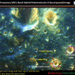
According to information obtained from the Indian Space Research Organisation (ISRO) Chandrayaan-2 Dual-Frequency Synthetic Aperture Radar (DF-SAR) satellite, the moon has been continuously bombarded by meteorites, asteroids and comets since its formation. This has resulted in the...
Tuesday, October 29th, 2019
NEW DELHI: India and the US are unlikely to sign a key foundational defence agreement for mutual access to high accuracy geospatial maps at an upcoming meeting between the defence and foreign leaders next month as technical...
Tuesday, October 29th, 2019
The House Committee on Homeland Security unanimously passed the Drone Origin Security Enhancement Act (H.R. 4753) on Oct. 23. The bill would bar the Department of Homeland Security (DHS) from operating, providing financial assistance for, or entering...
Tuesday, October 29th, 2019
Researchers at BAS and four Chilean research institutes tested the detection technique using images from Maxar Technologies of the biggest mass stranding of baleen whales recorded. Read More at Cambridge Independent
Tuesday, October 29th, 2019
Centre national d’etudes spatiales (CNES) President Jean-Yves Le Gall and Jean-Paul Moatti, Chairman and CEO of the Institut de recherche pour le développement (IRD), the French National Research Institute for Sustainable Development, signed a framework cooperation agreement...