Wednesday, March 25th, 2020
Haverhill, MA – Using all thermoelectrically cooled photodiode arrays and custom heating and cooling management features, the SR-6500A spectroradiometer is built specifically for high performance that demands unsurpassed drift stability. The SR-6500A features: Drift stability of ≤0.4%...
Wednesday, March 25th, 2020
Press Release: New York: Eka Software Solutions, the #1 cloud platform for commodity management, announced the release of COVID-19 Risk Monitoring, a free app designed to help customers and prospects quickly gain visibility into supply chain risks...
Wednesday, March 25th, 2020
Rome, New York – PAR Government Systems (“PAR Government”), a provider of geospatial and decision support solutions to the U.S. government for 50 years, has re-launched the popular GV3.0® raster imagery and full-motion video viewing package as...
Wednesday, March 25th, 2020
RangePro X8P (Pixhawk), the follow-up to the RangePro X8, is proudly designed and manufactured in the USA, with U.S.-made flight control system (FCS) components and highly secure radio options Valencia, CA — TerraView, a California-based unmanned aircraft...
Wednesday, March 25th, 2020
XICHANG -- China successfully sent a group of new remote sensing satellites into orbit from the Xichang Satellite Launch Center in southwest China's Sichuan Province on Tuesday. Read More at China Daily

Tuesday, March 24th, 2020
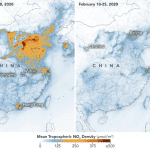
In countries and regions that have been under strict lockdowns to stop the spread of the coronavirus, an unintended consequence is visible from space. As businesses, industrial sites and factories closed, and cars and trucks stayed off...
Tuesday, March 24th, 2020
Challenges Status Quo with Imaging Precision, Flexibility and Affordability COPENHAGEN – Phase One Industrial, a pioneer in digital imaging excellence, today launched the 280MP Aerial Solution -- a large format aerial photogrammetric system, with an image...
Monday, March 23rd, 2020
(HEERBRUGG, SWITZERLAND) – Leica Geosystems, a Hexagon company, announced today its Leica Ready machine control kits will now be offered on Hidromek motor graders, a globally known manufacturer of construction machinery. The Hidromek Grader HMK600MG will now...
Monday, March 23rd, 2020
(HEERBRUGG, SWITZERLAND) – Leica Geosystems, a Hexagon company, announced today it is entering into a working relationship with Zoomlion Heavy Industry Science & Technology Co., Ltd., a manufacturer of major high-tech equipment in the areas of engineering...
Monday, March 23rd, 2020
Coronavirus cases have seen a significant jump in India this week with some death cases also reported. People worldwide are constantly checking on news updates to know the status of the virus in their country. Several companies...