Wednesday, May 27th, 2020
GfK's Map of the Month for May shows the regional distribution of purchasing power in Switzerland in 2020. According to GfK's latest study for Switzerland, first place in the district rankings goes to the district of Höfe,...
Wednesday, May 27th, 2020
MALA GPR Australia is proud to present MALÅ MIRA HDR, the new GPR array system. It’s the professional choice for large scale 3D GPR mapping and will help customers around the world to create detailed 3D maps of the subsurface with the highest resolution...

Tuesday, May 26th, 2020
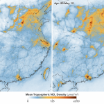
In early February 2020, scientists using NASA and European satellites detected a significant reduction in a key air pollutant over China after the country shut down transportation and much of its economy. Three months later, with most...
Tuesday, May 26th, 2020
Bremen, 26 May 2020 – The European Space Agency (ESA) has signed a contract with Airbus for the construction of the third European Service Module (ESM) for Orion, the American crewed spacecraft. The contract is worth around...
Tuesday, May 26th, 2020
As the country’s universities prepare for the move towards level 3 lockdown, the government is looking at possible technologies which could help improve remote-learning in the country, says minister of Higher Education, Science and Technology Blade Nzimande....
Tuesday, May 26th, 2020
As Nepal unveiled a new map of its territories this week, the country’s land management minister Padma Aryal called it ‘historically pleasant’ occasion. However, the move drew sharp criticism from India which said the map includes parts...
Tuesday, May 26th, 2020
Ordnance Survey has entered a contract to work with the Dubai Government in developing its geospatial capabilities. The landmark deal, a first for Ordnance Survey, will see Great Britain’s national mapping agency begin work with the Dubai...
Tuesday, May 26th, 2020
The first collective geospatial agreement for Great Britain allowing the public sector from England, Wales and Scotland to access Ordnance Survey (OS) geospatial data and expertise has been achieved. The Scottish Government and Geospatial Commission have agreed...
Tuesday, May 26th, 2020
BetterGIS is excited to announce its latest release of UVARA™, the leading intelligent infrastructure system for facility & construction management. Building on the strength of its turnkey solution for managing, tracking, and planning all aspects of existing...
Tuesday, May 26th, 2020
Intetics Inc., a leading global technology company providing custom software application development, distributed professional teams, software product quality assessment, and “all-things-digital” solutions, announced new corporate style in the celebration of its 25th anniversary. Intetics is expanding to...