
Asian Surveying & Mapping
Breaking News
EU and Korea deepen cooperation on secure satellite connectivity
Today, the European Commission and the Republic of Korea...
Ghana, Japan explore deeper cooperation in space technology
Ghana and Japan are exploring deeper cooperation in space...
China conducts four launches inside 48 hours as launch options diversify
HELSINKI — China carried out four launches in quick...
Dubai Municipality deploys smart robot for geospatial surveys
Dubai: Dubai Municipality has deployed a smart robot to...
India’s Geospatial Sector Gets Boost With Mirai-GreenValley LiDAR Partnership
Mirai Aerospace Systems and Software Solutions and US-based GreenValley...
From drones to space tech, Japan looks to startups to strengthen its defences
Tokyo is stepping up efforts to harness dual-use technologies...
South Korea’s Space Agency Seeks 47% Budget Hike for 2027; Regular Nuri Launches, Lunar Lander Development to Begin
The Korea AeroSpace Administration (KASA) has proposed a 2027...
Space42 launches Future Spacers Programme to develop UAE space talent
Space42, the UAE-based AI-powered SpaceTech company, has launched the...
US, China arm for space warfare: hunter satellites and orbital weapons
Amid the rapidly-evolving field of military space operations, Beijing...
ISRO Puts India’s First Geo Imaging Satellite In Orbit, PM Modi Hails EOS-05 Launch Aboard GSLV-F17
The Indian Space Research Organisation (Isro) successfully launched EOS-05,...
  • Dec 16, 2025
  • Comments Off on New Timing for Stubble Burning in India 
  • Feature
  • 865 Views

December 16th, 2025
New Timing for Stubble Burning in India 

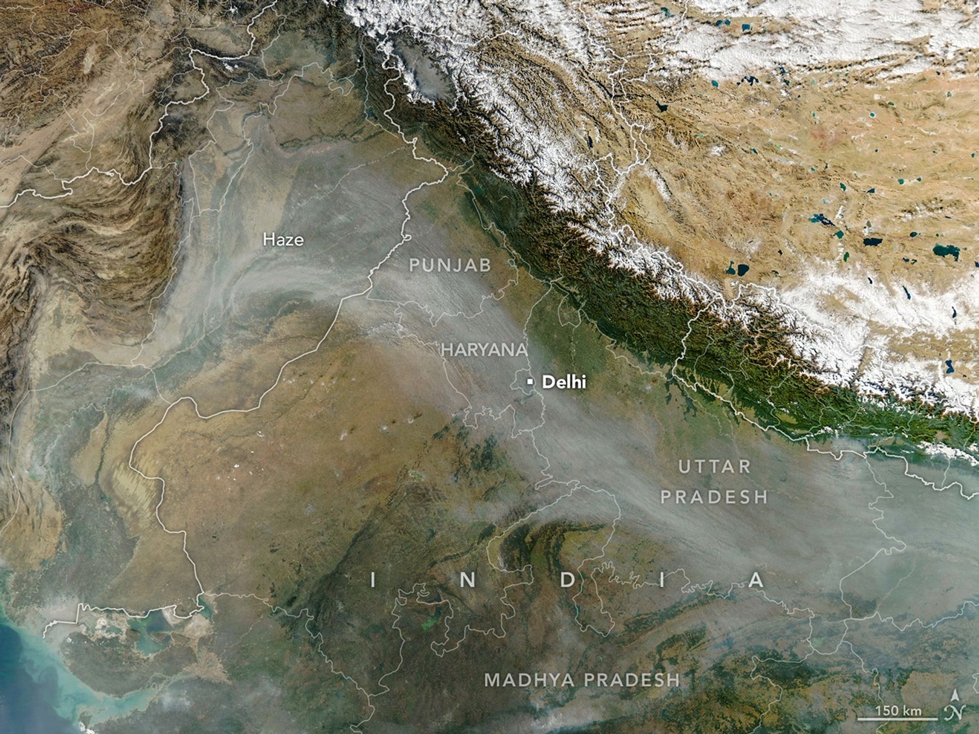
Every year for decades, long rivers of smoke and haze have spread across the Indo-Gangetic Plain in northern India from October to December. That’s when farmers in Punjab, Haryana, Uttar Pradesh, Madhya Pradesh and other states burn off plant “stubble” after the rice harvest. 

When winds are weak and the atmosphere becomes stagnant, the haze can push levels of air pollution several times higher than limits recommended by the World Health Organization. Smoke typically mixes with particles and gases from other sources, such as industry, vehicles, domestic fires (heating and cooking), fireworks and dust storms, to form the haze, though scientists consider stubble burning to be a major factor. 

The MODIS (Moderate Resolution Imaging Spectroradiometer) on NASA’s Aqua satellite captured this image of a smoky haze darkening skies over much of the plain on Nov, 11, 2025. According to news reports, it was the first of several days in 2025 when pollution levels exceeded 400 on India’s air quality index, the strongest rating on the scale. As in past years, the poor air quality prompted officials in some areas to close schools and institute more stringent air quality controls on construction. 

Image Credit: NASA Earth Observatory image by Michala Garrison, using MODIS data from NASA EOSDIS LANCE and GIBS/Worldview.