
Asian Surveying & Mapping
Breaking News
South Korea Tests First Indigenous Hypersonic Missile
South Korea conducted its first test-firing of an indigenously...
UAE space economy grows 27.1% to $1.5 billion
Findings also recorded an increase in employment across the...
Japan targets 30 rocket launches a year by 2030s
TOKYO -- Japan's economy ministry plans to add new...
China’s LandSpace Launches 10 Satellites to Advance Orbital Computing and Communications
China has launched eight computing satellites developed by ADA...
South Korea launches Nuri rocket carrying 15 satellites, its 1st liftoff of 2026
The milestone came on Tuesday night (Oct. 6), when...
Iran expands GPS network using Khayyam satellite data
Iran’s National Cartographic Center (NCC) is strengthening its cooperation...
India-Japan looking to deepen economic engagement, eye greater cooperation in chips, space: Suzuki
New Delhi, Oct 4: India and Japan are looking...
Genesys International bags ₹283 crore World Bank-funded contract for Ahmedabad digital twin
The project will map 625 sq km, survey 25...
China launches new remote sensing satellite group
TAIYUAN, Sept. 24 (Xinhua) -- China launched a new...
Ahmad Belhoul Al Falasi to lead UAE delegation at IAC 2026
UAE delegation will bring together government entities, research institutions...
  • Oct 20, 2026
  • Comments Off on Sentinel-1 Radar Reveals Typhoon Surigae’s Winds Beneath the Clouds 
  • Feature
  • 7 Views

October 20th, 2026
Sentinel-1 Radar Reveals Typhoon Surigae’s Winds Beneath the Clouds 

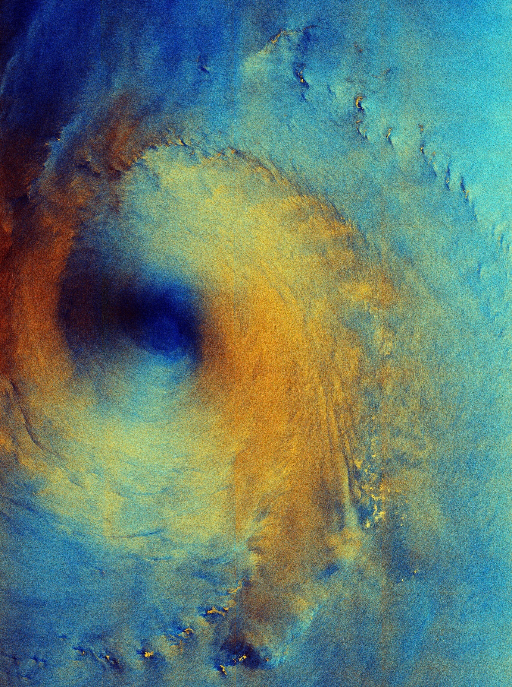
A false-color radar image captured by the Copernicus Sentinel-1 satellite offers an unusual view of Typhoon Surigae: not the familiar white spiral of clouds, but the rough ocean surface beneath the storm. The Sept. 28, 2026, image shows the typhoon in the Philippine Sea, roughly 200 kilometers south of Japan’s Shikoku island, as it moved northeast. 

The satellite’s radar instrument recorded two polarizations, which were assigned different colors to reveal variations in the sea-surface signal. The storm’s relatively calm eye appears dark blue, surrounded by a broad orange-yellow ring associated with rough seas and strong winds. Lighter blue areas represent different radar responses that may reflect variations in wind, wave conditions or rainfall. 

According to the European Space Agency, gusts reached as high as 240 kilometers per hour when the image was acquired, with waves up to 7 meters. Bright yellow flecks farther from the eye may look like islands, but ESA says they are more likely areas of concentrated wind and rain. The radar view demonstrates how Earth-observing satellites can detect ocean conditions even when cloud cover obscures the surface in conventional imagery. 

Image Credit: Contains modified Copernicus Sentinel data (2026), processed by ESA