The city of Pune has begun to map the city as a means of dealing with the challenges of an H1N1 outbreak that is taking place. “The task of mapping suspected areas has been taken up and further steps will be planned on these observations. Schools have been issued instructions to keep a watch on students, said Bankar,” reports the Times of India.
Thirty-three cases of the influenza have already been identified, and officials expect more to come due to the varying temeperatures. Mapping will help to identify impacted regions, and thus the spread and location of the influenza. At the same time this information can be readily used to assist in raising awareness and helping residents to understand the situation.
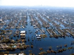
Spatial data also plays an important role in other disasters, such as the recent flooding in Australia. While maps can help actively during the crisis phases of disasters when the events are occurring, they can also be used to provide information about these events after-the-fact, aiding officials with needed information that helps to understand impacts, this mitigating future circumstances,
“Geoscience Australia will circulate a survey to a total of 1900 businesses to gather information on the impacts and losses attributable directly to the events as well as the disruptions they caused to business revenue and operations. It will seek details also on how businesses coped with that loss and disruption.”
Each of these cases demonstrates not only the use of maps, but the need for spatial data collection, and, a wider connection to the processes and systems linked to impacted areas. In the case of of Pune, demographic information is highly important.
The role of education and awarness should be underlined when considering the use of spatial data for disease and disaster events. Spatial data helps to inform, but it also provides a reality-check, supporting circumstances that are prone to disorganisation and misunderstanding, with accurate data to make the proper decisions.
Unfortunately we can expect many disasters in the future. Our responsibility is to meet these challenges with the tools and approaches that best respond, mitigate and help use to understand the best approaches for minimizing them.


