China announced this week that it would expand it’s seabed surveying and mapping operations. “China will accelerate its pace of mapping the deep seabed, Zhang Jixian, president of the Chinese Academy of Surveying and Mapping, told China Daily. Unlike the electronic navigation chart released by the Chinese navy on Aug 25 with information mainly focusing on navigation, the future ocean map will concentrate on the geological features of the sea floors and the water depth, and the location of reefs,” reported China Daily.
That country is not alone in terms of ramping up and pursuing increased seabed suveying opportunities. Earlier CSIRO reported that scientists from 5 different organisations in Australia were performing seabed mapping and surveying. “They examined the shelf seascape during a three-year program of the Commonwealth Environment Research Facilities (CERF) Marine Biodiversity Hub.”
Geoscience Australia has also been interested in such mapping, “Bathymetry has been used extensively by Geoscience Australia’s Law of the Sea Project to determine the foot of slope of Australia’s continental shelf, which, in turn, has been used to determine Australia’s extended continental shelf. Knowledge about the location of near-surface seamounts and reefs is useful also for the Australian Hydrographic Service to chart shipping hazards,” reports Geoscience Australia.
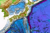
A history of the Survey of the Continental Shelf of Japan earlier described by The Secretariat of the Headquarters for Ocean Policy, Cabinet Secretariat, Government of Japan. In the case of Japan, the Port and Airport Authority says, “since Japanese coastlines are suffering from erosion of about 160 ha/year, comprehensive coastal management is required to prevent such massive beach erosion. The objectives of this research theme are to develop numerical models for predicting morphological changes in the nearshore region on the basis of results of field measurements and to propose effective coastal zone management systems.”
Currently, 97% of the world’s rare earth metals, used to create digital products, come from China. In July of 2011 it was reported that as much as 100 million metric tonnes of rare earth metals lie at a depth of about 3500 m in coastal waters near Japan. It is expected that other minerals may similarly be found within seabeds. An International Seabed Authority Handbook exists. It describes international seabed activities, individuals and organisations involved and some of the ongoing projects.
“New Zealand’s right to approximately 1.7m square kilometres of extended continental shelf seabed has been confirmed by the United Nations Commission on the Limits of the Continental Shelf. The extended continental shelf is the shelf that extends beyond New Zealand’s 200 nautical mile Exclusive Economic Zone (EEZ).” Meanwhile, Cambodia has requested that “the newly elected Thai government to resume talks on resolving claims to a 27,000-square-kilometer stretch of seabed considered rich in oil and gas.” That area bounds each country.
As seabed surveying and mapping increases, the International Seabed Authority is likely going to find more countries, like China’s approval to survey the Indian Ocean, wanting to seek claims and rights of use within these areas.


