Monday, January 9th, 2012
FUGRO-TSM Pty Ltd, has been awarded the Greater Western Flank (GWF) Phase 1 Project Subsea Installation Contract from Woodside Energy Limited. The contract value is in excess of AUD 100 million, with engineering and design work for the...
Saturday, January 7th, 2012
Strategic cropping land is an important, finite resource that is subject to competing land uses from the agriculture, mining and urban development sectors. The government aims to strike a balance between these sectors to help maintain the...
Monday, December 26th, 2011
The interdisciplinary research project CRC TR32: “Patterns in Soil-Vegetation-Atmosphere-Systems: Monitoring, Modelling and Data Assimilation” works on matter fluxes between soil, vegetation and atmosphere (SVA) on a regional scale. In this regard, high quality land use data is...
Sunday, December 25th, 2011
"Gloucester Coal has entered into a merger proposal deed with Yanzhou Coal Mining Company Limited and its wholly owned Australian subsidiary, Yancoal Australia Limited, following an approach from Yanzhou," Gloucester Coal said on Friday. Yanzhou Coal Mining, China's...
Thursday, December 22nd, 2011
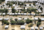
Last year saw extensive flood damage throughout the Brisbane, Australia area. Damage estimates were in the billions of dollars. Infrastructure was destroyed, crops were submerged and the energy industry was impacted significantly. The toll on human life...
Sunday, December 18th, 2011
Cutting-edge technology is enhancing the surveillance capabilities of biosecurity officers from the Department of Agriculture, Fisheries and Forestry (DAFF) and Indigenous ranger groups in Australia’s remote northern region. Community Liaison Officers with the DAFF Northern Australia Quarantine Strategy...
Wednesday, December 14th, 2011
Ed Linacre, an industrial design graduate of Swinburne University of Technology, Melbourne, has won the 2011 James Dyson Award for his Airdrop irrigation system. In developing the promising new irrigation-by-condensation technique, Linacre has captured the attention of...
Friday, December 9th, 2011
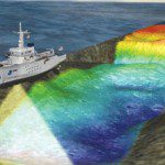
Marine surveys are conducted to acquire underwater geophysical information. In most cases, marine surveyors will acquire 3D data using sounding equipment. Sound reflections bounce off of underwater surfaces and are returned to survey ships detectors along carefully...
Wednesday, December 7th, 2011
Mipela GeoSolutions is opening a new office in Melbourne on Monday 9th January 2012. This is in line with one of the company’s “Twenty14 Strategic Plan” key objectives of expanding geographical presence. The Melbourne office has been opened to...
Monday, December 5th, 2011
THE WA ASTER (Advanced Spaceborne Thermal Emission and Reflection) map was recently released by the Centre of Excellence for 3D Mineral Mapping (C3DMM) and marks a milestone in mineral exploration putting WA at the forefront of geosciences. Director...
