Friday, October 21st, 2011
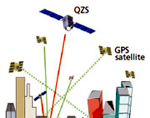
The Quasi-Zenith Satellite System (QZSS) is a constellation of multiple satellites, with at least one satellite positioned near zenith over Japan at anytime. The purpose of the system is to enable improved satellite coverage, thereby enhancing the...

Thursday, September 8th, 2011
Monitoring and mapping of oceanographic currents helps in understanding the movement of contaminants in ocean waters and estimating the impacts of climate change and to provide faster sea ship routes. The Korea Hydrographic and Oceanographic Administration has recently...
Thursday, September 1st, 2011
Pakistan plans to work with China, Japan and Europe to expand its network of remote sensing (RS) satellites for use in environment monitoring and natural resource surveys. The Pakistan Space and Upper Atmosphere Research Commission (SUPARCO) announced this...
Tuesday, August 16th, 2011
Government officials in Palau joined United Nations experts at a training workshop here on the use of satellite technology to improve the Pacific island nation’s preparedness for natural disasters that are a major threat to national physical...
Thursday, July 28th, 2011
An Australian company is poised to take advantage of growing frustration at the limitations of satellite-dependent global positioning systems. Professor Chris Rizos, of the School of Surveying and Spatial Information Systems at the University of New South...