Tuesday, May 2nd, 2017
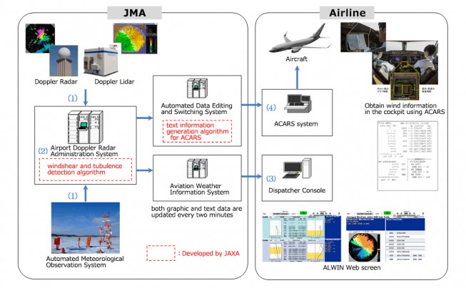
In April 2017, the Airport Low-level Wind Information (ALWIN) system, jointly developed by the Japan Meteorological Agency (JMA) and the Japan Aerospace Exploration Agency (JAXA), started operations at Tokyo International Airport (Haneda) and Narita International Airport. ALWIN...
Monday, October 12th, 2015
With the annual bush-fire season approaching, aviation-safety authorities and firefighters are concerned about the danger posed to large aircraft by people flying drones near bush fires. While last bushfire season in NSW required few aerial fire-bombing operations, Mr...
Thursday, September 3rd, 2015
Previously unreleased transport data, now available via a new innovative open data platform, is helping to make future transport solutions safer, easier and more efficient. Developed by VicRoads using the world’s leading smart mapping technology – Esri’s...
Thursday, May 15th, 2014
Traffic safety in Bangalore is the focus of a recent effort by a team of experts at the Indian Institute of Science to map incidents for improved roadway safety. The project is taking place with the cooperation...
Thursday, May 15th, 2014
There is awareness and retaliation against the harrassment of women worldwide given recent high-profile cases. The safety of women has been the focus of maps such as the Harassmap in Egypt, and now the Safecity mapping...
Monday, April 7th, 2014
A senior marine geoscientist says Australia would benefit from more detailed maps of oceans to help locate more economic resources and improve safety for boats. Scientists, surveyors and spatial industry experts are meeting in Canberra to discuss...
Thursday, April 3rd, 2014
One of the world’s leading mining geospatial experts is in Australia to advise resources companies on how cutting-edge mapping technology could change the future of the industry. During industry briefings around the country, Esri Mining Solutions Lead...
Thursday, March 6th, 2014
India's central government is working on an integrated location-based emergency response system to improve emergency response in communities. The project has been approved by the Indian Cabinet Committee on Economic Affairs after receiving a proposal from the...
Monday, February 10th, 2014
PenBay Solutions, the leading developer of GIS-based facility lifecycle management software, announced InVision 1.4 from the floor of the 2014 Esri Federal GIS Conference today in Washington, DC. Built on Esri® ArcGIS®, InVision integrates geospatial tools with...