Asian Surveying & Mapping
Breaking News
China sets historic Mars mission for 2028 as US plan remains in limbo
China is on track to launch its Tianwen-3 mission...
GNSS: Here’s how India’s new GPS-based toll system will change your highway travel
The Ministry of Road Transport and Highways has revised...
Shanghai Is Hit by Strongest Typhoon in Decades and Comes to a Standstill
Typhoon Bebinca, the strongest storm to hit Shanghai since...
Iran launches research satellite into orbit
TEHRAN: Iran on Saturday blasted a new research satellite...
Astha IT expands into Saudi Arabia with GeoTech
Astha IT, a US-headquartered leader in digital transformation and...
Nasa to launch project by Dubai student into space
A Dubai student's science experiment is being launched into...
China’s secretive space plane has returned to Earth. Its mission? Unknown
A Chinese “reusable experimental spacecraft” believed to be the...
China launches new set of classified Yaogan-43 satellites
HELSINKI — China launched a second group of classified...
China-Africa space cooperation benefits people across continent
The Egyptian satellite MISRSAT-2, a high-resolution optical remote-sensing satellite,...
Abu Dhabi astronomers discover new asteroid
ABU DHABI: The International Astronomical Centre in Abu Dhabi...

radar data

image

Thursday, March 24th, 2011

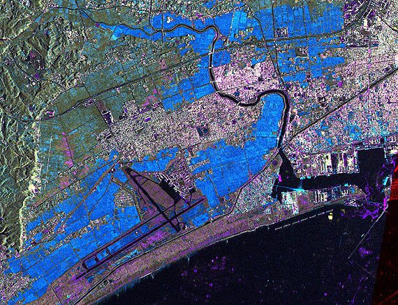
TerraSAR-X Satellite Data Reveals Destruction Caused by Tsunami in Japan

The German Remote Sensing Data Center (Deutsches Fernerkundungsdatenzentrum; DFD) and the German Space Operations Center (GSOC), both of which are part of the German Aerospace Center (Deutsches Zentrum für Luft- und Raumfahrt; DLR), are continuing to provide...

Wednesday, March 9th, 2011

Reminder – Remote sensing – The Synergy of High Technologies

On April 15 within the V International Conference “Remote sensing – the synergy of high technologies” Sovzond Company (Russia), MDA (Canada) and Kongsberg Spacetec (Norway) will organize a series of theme seminars on radar data application. Nowadays there...