Asian Surveying & Mapping
Breaking News
South Korea is converting an abandoned coal mine into a moon exploration testing ground
South Korea is transforming abandoned coal mines into testing...
ISRO to Launch Chandrayaan-5 With Japan, Plans Space Station
Dr. V. Narayanan, Chairman of the Indian Space Research...
Russia and China are threatening SpaceX’s Starlink satellite constellation, new report finds
SpaceX's Starlink satellite constellation is facing threats from Russia...
China and Pakistan agree to fly 1st foreign astronaut to Chinese space station
For the first time, the Chinese space program will train...
ISRO’s “Space on Wheels” offers a peek into Indian Space Programme to students in Karimnagar
The Indian Space Research Organisation (ISRO)’s “Space on Wheels”...
Geospatial led solutions build the foundations for better decision-making
Geo Connect Asia 2025 paves the way for turning...
GEOSA, Singapore Land Authority Launch Achievements of Joint Geospatial System Project
Riyadh, SPA -- The General Authority for Survey and...
Building in Bangkok collapses as powerful earthquake hits southeast Asia
One person has died and 50 were injured in...
Bellatrix Aerospace Partners with Astroscale Japan for Space Debris Removal
Bellatrix Aerospace, a Bengaluru-based space mobility company, has joined...
NSTC announces Pingtung site as Taiwan’s space mission launch center
Taipei, March 26 (CNA) Taiwan's National Science and Technology...

maritime

Wednesday, April 6th, 2011

1Spatial Delivers Real-time Counter-piracy Alert System

Untitled document

 1Spatial, provider of intelligent data quality and integration solutions, has delivered to Pole Star...

Wednesday, March 2nd, 2011

Scientists to Investigate Five Major Submarine Volcanoes

A New Zealand-led group of international scientists will spend the next three weeks on NIWA’s research ship Tangaroa, using a free-diving robotic vehicle to investigate mineral deposits and hydrothermal activity at five major submarine volcanoes in the Kermadec...

Tuesday, February 22nd, 2011

C-Nav Announces Latest C-Nav3050 Advances

C-Nav has announced the latest advances to its C-Nav3050 GNSS receiver. The C-Nav3050's latest range of advances include the addition of dynamic RTCM outputs and choice of either NTRIP client or server mode operation. The latest enhancements also...

Tuesday, February 22nd, 2011

C-Nav Chosen for Osiris Projects Vessel

C-Nav, the premier supplier of international GNSS Precise Point Positioning services, will provide the GNSS positioning system for Osiris Projects latest new-build survey vessel, the SV Bibby Tethra. C-Nav has been chosen to provide...

Thursday, February 10th, 2011

GNSS and Maritime Navigation Technology

Few people would argue about the importance of navigation communication systems and the contribution they have made to ocean going vessels worldwide. From dead-reckoning to the present day GNSS enabled navigation,...

Tuesday, February 1st, 2011

Space Images – Used to Find “Partner” Schooner

Satellite radar imagery data was used to find the “Partner” fishing schooner lost in the Sea of Japan. According to Russian EMERCOM the area search operations for the “Partner” schooner that sent a distress call on January...
Thursday, November 25th, 2010

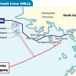
Value of a Map: North Korea – South Korea

This past week saw North Korea launch live ammunition into South Korea. The event has raised tensions in the region. While the original border between these two countries was mapped when the Armistice was signed in 1953,...

Saturday, June 16th, 2007

Low Level Risk of Flooding

Almost 247 million people live in low elevation coastal zones, according to figures in a paper published in the journal Environment and Urbanisation. Scientists from the Centre for International Earth Science and the International Institute for...

Monday, April 16th, 2007

Mapping the Indonesia-Singapore Border

It seems that tension is building between Indonesia and Singapore. The major cause for concern is the issue of the maritime boundaries between the two neighbouring states, following coastal reclamation by Singapore. It has raised questions...

Page 2 of 2 1 2