
Sunday, March 13th, 2011
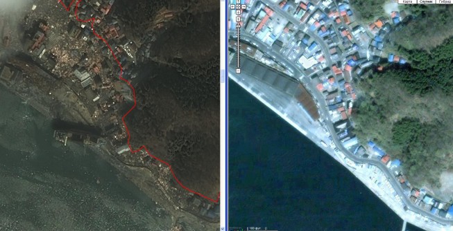
Detailed satellite images of the territory of Japan were received, where a series of earthquakes were registered on March 11 in its north-eastern parts. According to the Main Meteorological Service of the country the 8.9 magnitude earthquake...
Tuesday, March 8th, 2011
Satellite pictures showing the extent of Libya’s refugee problem have emerged. The GeoEye-1images reveal a mass of people at the Ras Ajdir crossing at Libya’s border with Tunisia. But they only indicate scale, not detail. The satellite pictures taken on...
Wednesday, February 23rd, 2011
Activists say there is no accurate map showing the extent of the deforestation because of incomplete information given by local provinces, and the inaccessibility of the archipelago's remote and rugged terrain. Satellite imagery is also hindered by...
Monday, January 17th, 2011
LPS is a powerful, workflow-oriented photogrammetry system for production mapping, including full analytical triangulation, the generation of digital terrain models, orthophoto production, mosaicking, and 3D feature extraction.
Tuesday, January 4th, 2011
PixAgri is a comprehensive service, available worldwide, that gives farming professionals more control over practices and inputs to achieve maximum profitability, by delivering field-level maps providing crop status information to help you make the right decisions. PixAgri provides...
Thursday, December 16th, 2010
ESA's Earth-observing satellites are helping to understand the intricate role that Eurasia's boreal forest – the planet's largest land ecosystem – plays in the chemical make-up of the atmosphere and the global climate system.
Tuesday, December 14th, 2010
Shorelines present complex environmental and engineering issues to those charged with their management. These issues are becoming more difficult and more political, particularly in SE Asia where people are only now seeing the multi-faceted benefits of coastal...
Thursday, July 16th, 2009
A new milestone has been reached: this month the Western Australian archive of RapidEye satellite imagery has surpassed 1.75 million sq km. Satellite imagery coverage over Western Australia has increased significantly in the past four months. Almost...
Monday, January 5th, 2009
Prof. Deren Li of Wuhan University in China has received an honorary doctorate degree from ETH (Federal Institute of Technology) in Zurich. Li is renowned for his contribution to photogrammetry, remote sensing and GIS and is a...