Asian Surveying & Mapping
Breaking News
Intermap Announces $1 Million Program in Malaysia and Business Updates
DENVER – Intermap Technologies (TSX: IMP; OTCQB: ITMSF) (“Intermap” or...
From Kuala Lumpur To Singapore: Malaysia’s High-Speed Rail Resurgence Sparks China’s Pan-Asia Vision
The Malaysian government is once again working on building...
Japan’s Synspective successfully launches fourth SAR satellite
Synspective, the Japanese provider of Satellite/Synthetic Aperture Radar (SAR)...
South Korea’s Joowon Industrial Selects Aeva 4D LiDAR for Automated Power Line Inspection Program
MOUNTAIN VIEW, Calif. & SEONGNAM CITY, South Korea- Aeva®...
Synspective’s SAR Satellite, StriX-3, Successfully Reaches Its Target Orbit and Spreads Its Wings
TOKYO, 2024, March 13 – Synspective Inc., a SAR...
Indian Prime Minister Narendra Modi Commissions Genesys Digital Twin Map Stack in His Parliamentary Constituency
Mumbai: The Prime Minister of India, Mr. Narendra Modi, recently...
Geo Connect Asia 2024 to unveil geospatial’s transformative power
Geo Connect Asia (GCA) is set to return to...
Iran launches ‘domestically developed’ imaging satellite from Russia
The launch of Pars 1 is fourth this year,...
Astranis relocating hobbled debut satellite from Alaska to Asia
TAMPA, Fla. — Astranis is moving its debut satellite...
Asia space race heats up as China, Japan and India reach for the stars
After another year of US aeronautics company SpaceX dominating...
SNO_3_1

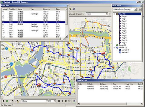
In addition, the road hierarchy function can find the route analysis that is closer to the real situation. For instance, when users intend to find a route from one to another with Shortest Path solver, the solution exhibits the shortest distance but might not be the most suitable one as it may pass areas where often suffers traffic congestion. Or, the route may not fit user’s real experience.


However, with road hierarchy function, the system can suggest the route according to the road hierarchy and swiftly find the route planning results catering to users’ demands. In other words, the new road hierarchy function can enormously enhance the performance of algorithm to solve problems, allowing users to find the solutions that are most conformed to their habits of road use.

The latest free trial of SuperNetObjects 3 is available at www.supergeotek.com.