Asian Surveying & Mapping
Breaking News
Safran, SatSure partner to develop geospatial intelligence solutions for India
French aerospace giant Safran Electronics & Defense and Indian...
Singapore unveils road map to help develop international business standards and conformance
Singapore has unveiled plans to help develop international standards...
Adelaide University to run space and defence venture launchpad ahead of Australian Space Forum
Adelaide University’s Innovation & Collaboration Centre (ICC) will deliver...
Japan’s H3 rocket returns to space with successful launch after December setback
Japan’s flagship H3 rocket has returned to flight six...
KONGSBERG accelerates seabed mapping developments with Ocean Exploration Trust expedition aboard Exploration Vessel Nautilus
KONGSBERG and the Ocean Exploration Trust (OET) are set...
Russian satellites linked to mysterious GPS disruptions across several countries
Since 2019, GPS signals across Europe, Greenland and Canada...
Isro’s Bahubali LVM3 that launched Chandrayaan-3 to be handed to private sector
IN-SPACe has invited Indian companies to take over the...
India to host 13th UN Global Geospatial Information Management Asia-Pacific Conference
India is hosting the 13th United Nations Global Geospatial...
Unseenlabs’ BRO-22 to Become the First Foreign Private Satellite Launched Aboard Japan’s H3 Launch Vehicle
Scheduled for June 10, between 09:53 and 11:52 a.m....
PLD Space increases investment in its Launch Complex at the Guiana Space Centre (CSG) to €35M, strengthening Europe’s sovereign space infrastructure
The investment is expected to generate approximately €21 million...

April 19th, 2011
Internet-based Early Warning System Against Floods

pn201101-10_072dpi

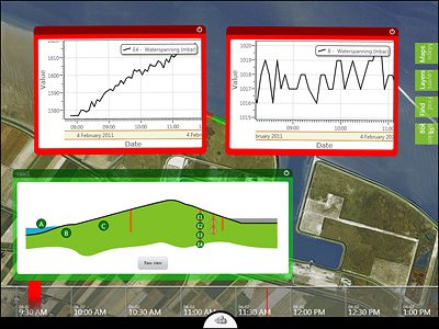
An international consortium of which Siemens is a part is currently developing new technologies for flood protection in order to create a global monitoring system. For the experimental dikes (in the Netherlands) built for “UrbanFlood,” the most important elements are sensors and learning software. The researchers allow a dike to erode in a targeted manner in order to find out what happens during a dike break. They then use the measured data to adjust the software and develop forecasting procedures. The idea goes back to Siemens researcher Bernhard Lang, who with his work won the Siemens-wide idea competition for sustainability in the category “Sustainable Portfolio Ideas.” An additional test has been underway since 2010 on the Livedijk. The system continuously monitors the barriers, indicates weak points, and warns if there is threat of breakage. The project is set to run for two years. www.siemens.com