Demos at GIS-Transportation 2023 in Oklahoma City
CENTENNIAL, Colorado, 4 April 2023 – CompassCom Software has introduced the next-generation CompassLDE Connectors for Esri ArcGIS solutions that enable users to view real-time asset location and status information in their ArcGIS maps and perform back-end analysis of operational data. CompassLDE Connectors improve personnel safety, enhance operational efficiency, and achieve sustainability goals.
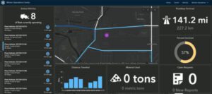
Example of Esri Velocity dashboard.
“The new plug-and-play CompassLDE Connectors now allow Esri users at every ArcGIS product level to display live location and status details of their vehicles, personnel, and equipment on their GIS screens,” said CompassCom CEO W. Brant Howard. “Power Esri users will be able to tap into CompassLDE telemetry with their big data analytics applications to extract valuable insights into their operations.”
There are CompassLDE Connectors for three Esri products available from CompassCom:
Embraced across North America by public works, public safety, street maintenance, and transportation departments at the state and local government levels, CompassLDE (Location Data Engine) was developed as an Automated Vehicle Location (AVL) data engine. Later upgraded as a mobile resource management solution to track any GPS-enabled device, CompassLDE is now a universal on-premises or cloud-based server capable of monitoring thousands of assets in multiple fleets over all wireless communications networks.
CompassCom has enhanced the latest version of CompassLDE to gather an almost limitless array of sensor inputs, referred to as telemetry, from assets in the field. Primarily related to vehicle activities, these include Ignition On/Off, Engine Diagnostics, Idle Time, Material Spreader On/Off, Plow Up/Down, Miles Traveled, and other data points. The server can even keep track of how much sand or chemical has been applied by a snowplow, for example.
“The CompassLDE Connectors push all this valuable data out to the Esri platforms and analytics workflows integrated with them,” said Howard.
For ArcGIS Online users, the primary advantage of the CompassLDE Connector is the improved situational awareness and better decision making that comes with seeing asset locations and status in real time. Vehicle fleet managers can perform live queries to view which snowplows have activated their spreaders and which ambulances are on a call, for instance. Alerts can be triggered when a police cruiser has left its geographic jurisdiction or other changes in status have occurred.
The extraordinary value of real-time data processing, however, will be realized by users of the GeoEvent Processor and Velocity Connectors. These Connectors transmit all telemetry data gathered by CompassLDE to the big data analytics applications, dashboards, and workflows that have been integrated on the back ends of GeoEvent Processor and Velocity – regardless of whether they are Esri, third-party or user built.
“The real-time management of snow plowing, emergency response, and street maintenance becomes more efficient through live data analysis,” said Howard. “Dispatchers can be notified when snowplows are running low on sand and be advised which available ambulance or maintenance crew has the right personnel and equipment to handle a call.”
For improving operations after an event, a back-end work order management system can place orders to replenish de-icing materials in preparation for the next storm or flag a vehicle for repair in response to engine diagnostics. Dashboards, such as Esri’s Velocity WinterOps application, can instantly determine the total cost of snowstorm response. And engine idle time can be tallied to calculate vehicle emissions that can be refined for more environmentally sustainable fleet operations in the future.
“CompassLDE Connectors empower Esri GeoEvent Processor and Velocity users to fully exploit the significant investments many have made in integrating big data analytics into their GIS platforms,” said Howard.
CompassCom will demonstrate the CompassLDE Connectors for Esri products at the AASHTO/GIS-Transportation Symposium 2023 being held April 11-14 in Oklahoma City.
For more information and to schedule an online demonstration, visit the CompassCom website at https://compasscom.com/products/esri-connectors/.
About CompassCom
CompassCom has been at the forefront of the Automatic Vehicle Location and MRM industry since 1994, providing enterprise-level fleet management solutions using the Esri ArcGIS platform. Originally designed for tracking the locations and status of vehicles, the CompassTrac® app and CompassLDE® server products are now used to monitor smartphones, private mobile radios such as Motorola and any mobile assets equipped with GPS telematics. CompassCom mobile resource management solutions are used across North America by local governments, public safety agencies, public works departments, DOT and other organizations managing vehicle fleets and mobile field crews.
For more information, visit www.compasscom.com or call 1-303-680-3311.
