MARKHAM, Ontario, Canada – CATALYST, a PCI Geomatics brand, is collaborating with Amazon Web Services (AWS) to take satellite-based earth observation intelligence to the mainstream business community via AWS Cloud. The CATALYST-AWS collaboration will deliver actionable geoscience analytics to users with any level of technical expertise.
By leveraging satellite imagery and analytics natively on AWS, insights can be delivered in hours instead of days to protect critical infrastructure and human lives.
CATALYST and AWS’s disruptive approach will make geospatial information accessible, affordable and consumable across all industry domains to produce better business decisions and investments,” said June McAlarey, President and CEO of PCI Geomatics. “The power of earth observation science has remained in the exclusive geospatial realm for too long.”
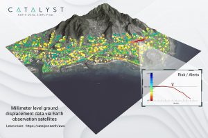
CATALYST’s initial solution, available through AWS Data Exchange, is an infrastructure risk assessment service that uses satellite data to continuously monitor millimeter-level ground displacement over a subscriber’s area of interest anywhere on Earth. CATALYST is exploring additional risk mitigation solutions and monitoring services using AWS.
CATALYST is transforming how industries and the general population leverage geospatial science by collaborating with cloud providers such as AWS. Together, CATALYST and AWS have co-located industry-leading image processing science and imagery on the cloud, reducing latency and costly data transfers.
“We deliver actionable business outcomes from satellite data in hours, as opposed to days,” said McAlarey. “More significantly, users of our solutions no longer need to be geospatial experts to cost effectively derive analytics, regardless of industry application.”
For details on subscribing to CATALYST’s Insights Solutions, visit https://catalyst.earth/aws.
CATALYST – Earth data, simplified
CATALYST, a PCI Geomatics brand, was introduced to disrupt how the world thinks and leverage earth observation intelligence to ensure a manageable and sustainable Earth for future generations to come.
