A new era for geospatial applications
Toulouse, 20 May 2021 – Today, Airbus released a first collection of sharp images at 30cm native resolution from the Pléiades Neo 3 satellite, recently safely launched and secured in orbit. The successful acquisitions and delivery of these first images are the start of a new era for both commercial and government geospatial applications requiring a high level of accuracy and the ability to see fine details.
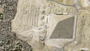
PNeo-first-image-Cairo-Copyright-AirbusDS2021
The Pléiades Neo 3 images, covering a variety of global locations and featuring diverse acquisition angles, provide an impressive level of detail. In one it is easy to count each and every limestone block of the Giza Pyramids, and even the number of people visiting. The multi-layered construction of Castel Sant’Angelo across the years can also be seen in detail in another. Urban areas and modern architecture, and their comprehensive diversity, are clearly visible in the images over Shanghai, Dubai and Washington DC.
These already very sharp images were acquired before full radiometric and system calibrations and the quality will continue to improve over the next few months. Imagery from Pléiades Neo 3 is expected to become commercially available in the third quarter 2021, after these calibration steps are completed.
With the full capacity of the satellite available for commercial use, the very high-resolution and geometrically consistent Pléiades Neo 3 imagery will provide analysts with a high level of detail, including more visibility of small objects, such as vehicles and road markings. This level of detection, recognition and identification of objects provides more ground truth for image analysts and improves reliability for machine learning capabilities. The new constellation will also provide a higher geolocation accuracy and deeper spectral band information, allowing more insights to be derived for various applications.
The Pléiades Neo constellation will be comprised of four identical and very agile satellites, offering reactive tasking and intraday revisit of any point on Earth. Entirely funded, designed, manufactured, owned and operated by Airbus, each satellite will add half a million km² per day at 30cm native resolution.
The next milestone of the Pléiades Neo programme is the launch of Pléiades Neo 4, which is already at the launch site in Kourou, French Guiana. It is expected to launch in summer 2021, followed by the launch of Pléiades Neo 5 and 6, in 2022.
@AirbusSpace #PléiadesNeo #SpaceMatters
