SPH Engineering announced that the Velos UAV helicopter has passed field tests to become the first single rotor helicopter supported by the UgCS software. UgCS now enables Velos helicopter professionals to use Velos for photogrammetry and LiDAR drone surveying missions.
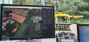
UgCS is now able to support the twin-engine telemetry providing input for a UAV. The newly created Telemetry Viewer can handle extensive telemetry from such complex drones. This allows for optimal flying of the Velos helicopter, the safest UAV in its class, with a fully redundant twin-motor design and double key components. UgCS makes piloting easier and safer, allowing for the control and monitoring of one or multiple Velos helicopters on a single mission in both single and multi-operator modes.
The field tests were initiated and conducted by Irish GeoInspect, the first company to use UgCS with its Velos helicopter. The new solution allows professionals to fine-tune projects, resulting in maximum performance and very high usability. One of the projects was a fully autonomous test flight with UgCS.
Bart Zondag, GeoInspect Founder, explains: “GeoInspect has been performing LiDAR surveys successfully with UgCS for many years. Having started with the M600 model, UgCS is now used to support single rotor UAVs. We have already delivered a Velos V2 with UgCS to one of our customers to the EU Nordics to perform LiDAR forestry surveys”.
Learn more about the solution by joining a free Zoom webinar on March 4, 2021.
About SPH Engineering
SPH Engineering (sph-engineering.com) is a multiproduct drone software company and UAV integration services provider. Founded in 2013 in Latvia (EU) as a UAV mission planning and flight control start-up, the company has evolved from a developer of a single flagship product (UgCS) to a market leader of multiple drone solutions. Today, the company boasts a rich global customer and reseller network in 150+ countries, while over 45% of partners are located in North America. To provide high-quality solutions for UAV professionals, SPH Engineering’s team advances four key product lines: UgCS (mission planning and flight control software), UgCS Integrated Systems (airborne integrated systems with sensors from diverse manufacturers), Drone Show Software (only commercially available software to manage drone swarm flights) and ATLAS (AI platform to process and analyze geospatial data).
About Velos
Velos Rotors (www.velosuav.com) has been producing high quality UAV helicopters since 2014 for customers in the US, Europe and Asia. Velos is simple to fly while offering high reliability, flight time and payload capacity. The drone was designed with three main objectives in mind: safety, efficiency and reliability. Velos is the safest UAV in its class and the best tool for demanding and critical projects where reliability and effectiveness are key. Examples include rescue missions, human organ transportation, and the use of expensive and sensitive sensors in demanding survey missions.
About GeoInspect
GeoInspect Ltd (geoinspect.eu) is an Irish consultancy and survey company with many years of experience in the acquisition and processing of LiDAR data. The company helps customers worldwide select the right components (platform and sensors) to execute their projects. With the Velos single rotor helicopter, GeoInspect found the right platform not only for surveys, but also for delivery projects. During such projects, UgCS is recommended as the optimal software for flight planning and pilot support.
