Lake Mary, Florida – FARO® Technologies, Inc. (NASDAQ: FARO), a global leader for 3D Metrology, AEC (Architecture, Engineering & Construction), and Public Safety Analytics, today announced the release of its new FARO Zone 3D 2021 software for crime, crash, fire and security applications. The latest edition of FARO Zone represents a significant software advancement that empowers public safety professionals with even more tools to diagram, document, share and analyze forensic scenes, and create compelling 3D scene reconstructions that bolster courtroom cases whereby jurors can walk through a forensic scene with an exceptional level of realism.
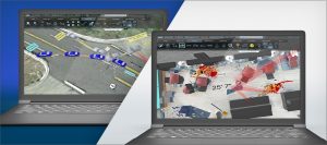
For forensic investigators, FARO Zone 3D 2021 provides the ability to accurately reconstruct any scene with the most complete and accurate documentation available, including factual diagrams, detailed reconstruction analysis and photo-realistic visuals such as grass that grows, multiple light sources and enhanced textures for stone, brick, wood, metal and water. Additional new features include analysis of blood cast off stains, bullet trajectories through multiple surfaces, automatic import of popular crash Event Data Recorder (EDR) data, a 3D roof builder, more than 50 new human models, and a new vehicle models and specifications database.
For FARO® Laser Scanner users, the new FARO Zone 3D 2021 “Advanced” option has all new tools to register scan data into a 3D point cloud and merge point clouds from multiple sources including drones. Once a scene is preserved as a point cloud, it can be used to digitally obtain accurate measurements, analyze the evidence, verify a witness perspective, animate crashes, and more. The Advanced option also creates custom virtual reality scenarios so users can ‘enter’ any scanned scene to take photos and measurements, pick up evidence, and swab for DNA samples, all while completely immersed in VR.
FARO Zone 3D 2021 also features Zone 2go, whereby professionals can create comprehensive presentations with multiple views of the scene, diagrams, reports, photographs, animations, and fly-throughs. The self-running viewer can be exported to a USB flash drive and, since no internet connection is required, it is ideal for jury observation and deliberation.
“For public safety professionals, measuring and documenting a scene is a critical aspect of the job and one that requires total accuracy,” said Janice White, Director of Software Product Marketing at FARO. “We believe that FARO Zone 3D 2021 provides the most comprehensive scene documentation software on the market today, with even more stunning results and compelling visuals than previous versions.”
“Crash reconstruction isn’t about creating Hollywood theatrics; it’s about finding truth through science,” stated Carl Lakowicz, a crash reconstruction expert from Northpoint Collision Consultants who shows jurors the whole picture through the 3D visualizations he creates. “FARO Zone 3D is what I use to show the science of a crash.”
Among other products, FARO Zone 3D 2021 will debut at the inaugural Public Safety & Forensics Tech Summit, held tomorrow (December 9) starting at 11:00 am ET. This free 24-hour virtual event focuses on how investigators can utilize 3D data capture technology to gain public trust and more accurate scene documentation. The conference will bring together officials from around the globe to discuss the latest developments in 3D scanning technology and how new products are moving the industry toward more transparent, holistic data capture. To register or learn more, visit https://www.psftechsummit.com.
For more information about FARO visit: www.faro.com
