Vexcel Imaging announced today the release of its UltraMap photogrammetric workflow software version 4.5. With the introduction of oblique AT, a new camera modeling procedure and a custom-developed earth curvature correction, the UltraMap team realizes its vision of optimal aerial geometry.
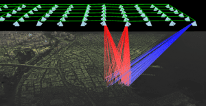
The new enhancements are multiple. First, the new release includes substantially improved tie points for obliques and a full photogrammetric bundle adjustment for all viewing directions through targeted use of selected nadir and oblique images for AT. This also allows for a more robust treatment of specific cases such as missing tie points in nadir. Secondly, the newly introduced Accurate Camera Modeling (ACM), based upon the Temperature Dependent Modeling (TDM), further improves the geometry for all 3rd generation UltraCam systems. The third step leading to optimal geometry is the implementation of a refined process for earth curvature corrections with a significantly positive effect on oblique image accuracy. Finally, UltraMap 4.5 comes with a new option for tie point thinning allowing for the reduction of tie points.
“Vexcel is consistently working to improve our UltraMap software workflow to deliver more value to our customers,” said Alexander Wiechert, Vexcel Imaging CEO.” UltraMap users are sure to appreciate this new version for its improved overall georeferencing which augments the precision of building textures, the enhanced accuracy of 3D models, and the precise measurements in nadir and oblique imagery.”
UltraMap v4.5 is available for all customers currently under service contract or within a valid UltraMap subscription license. An additional dongle license update is necessary.
About UltraMap
The highly automated, powerful and intuitive UltraMap photogrammetric software suite turns raw UltraCam data into high-value information delivering unrivaled point clouds, DSMs, ortho imagery and 3D textured TINs. Learn more about UltraMap.
About Vexcel Imaging
Developing cutting-edge digital aerial cameras, mobile mapping systems and photogrammetric software with innovative approaches beyond well-trodden paths together with constant product upgrades and a world-class support has made Vexcel Imaging one of the market leaders in this area.
High-resolution aerial UltraCam imagery along with derivative 3D data products is being offered through the Vexcel Data Program (VDP), a cloud-based imagery service providing the most diverse image collection of its kind. For more information, visit www.vexcel-imaging.com.
