Heerbrugg, Switzerland – Leica Geosystems, part of Hexagon, announced today a new collaboration with Autodesk, integrating the Leica iCON iCT30 construction layout tool and Leica Viva TS13 and TS16, and Leica Nova TS60 and TM50 total stations with the Autodesk BIM 360 Layout App.
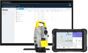
The Leica iCON iCT30 construction layout tool and Leica Viva TS13 and TS16, and Leica Nova TS60 and TM50 total stations are now integrated with the Autodesk BIM 360 Layout App.
With a focus on bringing more efficiency through digitalisation to the building construction industry, Autodesk and Leica Geosystems are collaborating on various projects to integrate technologies. In this latest collaboration, users are experiencing quicker and more productive time by connecting layout tool and total stations directly to the BIM 360 Layout app, now also available in Android, for immediate use on the site.
“Being able to accurately measure onsite, and now having those measurements directly in the BIM 360 Layout App, we are seeing less time spent on layout and more time spent on value-added activities for our construction clients,” said Chad Lansford, an estimator at Sare Electric, Inc., and long-time user of Leica Geosystems total stations. “We are expanding digital layouts to more and more projects, and we are seeing the increased benefits of adopting digital technologies throughout the industry.”
Digital construction layout for entry-level to survey-grade
Expanding upon the Leica iCON iCR70 and iCR80 robotic total station integrations last year, the iCT30 construction layout tool is an easy-to-use and affordable solution to increase productivity by minimising labour time and mistakes, while increasing accuracy and speed. The iCT30, just released earlier this year, is an entry-level construction layout tool built for one-person layout tasks in construction. The Viva and Nova series total stations have long been found throughout construction sites for their well-known survey-grade accuracy and reliability. Integrated into the BIM 360 Layout App, Autodesk’s unified construction platform for collaborative design, planning and management, the collaboration brings a new era of efficiency to the industry.
“Autodesk is empowering construction companies to increase efficiency by allowing data to seamlessly flow from design through to building and turnover,” said Josh Cheney, Industry Manager, Construction Technology at Autodesk. “Our collaboration with partners such as Leica Geosystems makes it easier for any construction team member, not just those with specialised training, to manage the layout process and take advantage of best-in-class technology. Together, we’re helping close the communication gap between the office and field so teams build accurately the first time.”
“In the building construction industry, we are seeing a move to become more digital on site, leaving analogue methods, especially in layout, behind,” said Bernd Moeller, Leica Geosystems business director for field software solutions. “To support this move, we are consistently looking at ways to bring more digital solutions to the field. Our continued relationship with Autodesk is just one such way, bringing both our customers and theirs in the industry new ways of working more efficiently and productively.”
Leica Geosystems – when it has to be right
Revolutionising the world of measurement and survey for 200 years, Leica Geosystems, part of Hexagon, creates complete solutions for professionals across the planet. Known for premium products and innovative solution development, professionals in a diverse mix of industries, such as aerospace and defence, safety and security, construction, and manufacturing, trust Leica Geosystems for all their geospatial needs. With precise and accurate instruments, sophisticated software, and trusted services, Leica Geosystems delivers value every day to those shaping the future of our world.
Hexagon is a global leader in sensor, software and autonomous solutions. We are putting data to work to boost efficiency, productivity, and quality across industrial, manufacturing, infrastructure, safety, and mobility applications.
Our technologies are shaping urban and production ecosystems to become increasingly connected and autonomous — ensuring a scalable, sustainable future.
Hexagon (Nasdaq Stockholm: HEXA B) has approximately 20,000 employees in 50 countries and net sales of approximately 3.8bn EUR. Learn more at hexagon.com and follow us @HexagonAB.
