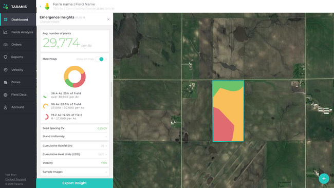
TEL AVIV, Israel – Precision agriculture intelligence leader Taranis, today announced the launch of its new solution that calculates and monitors the planting of seeds. Taranis is the first platform to offer farmers and agronomists a scalable answer to plot management strategy. The addition of an emergence solution to the company’s offerings reflect Taranis’ vision to become the single-most comprehensive precision agriculture intelligence platform provider.


While the demand for a stand count solution is high, historically it has been difficult for companies to create due to scalability. After extensive testing on thousands of acres of land across USA, Canada, Brazil, and Argentina, Taranis was able to use its market leading insights and patented AI2 technology to successfully overcome this challenge, enabling growers, consultants, retailers, and manufacturers to measure the vigor of a seed across thousands of acres of land.
“Taranis understands the value of emergence in crops and supplying farmers with the necessary tools to increase crop yields has been our priority since day one,” says Ofir Schlam, CEO of Taranis. “We have grown to accommodate our customers’ needs, offering products that utilize Taranis’ unmatched fleet of UAV’s to provide unparalleled protection against crop threats. This first-of-its-kind crop emergence and stand count product can continually and rapidly take samples throughout the field, providing farmers with new tools that will make emergence-based decisions easier.”
Studies confirm that uneven emergence or loss of seeds can affect grain yields by up to 6-7%, or roughly a loss of 12 bushels per harvest. As seed is one of the highest inputs a grower deals with on a yearly basis, this can be catastrophic for a farmer’s bottom line. By surveying the fields after planting season with Taranis’s technology, customers can take targeted tissue and soil samples to create management zones, ultimately maximizing fertilizer programs.
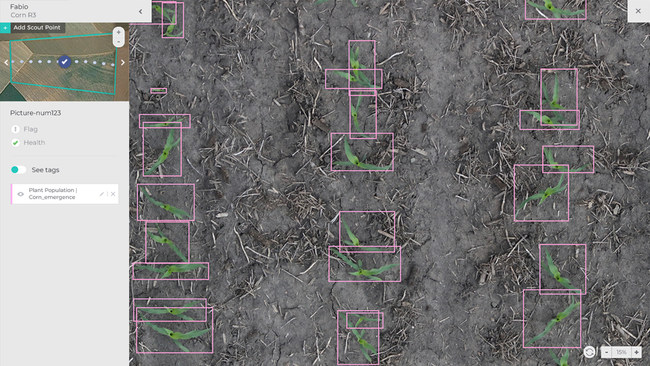
As part of its solution, Taranis flies a drone or aircraft over a field using the company’s patented AI2 proprietary pod, which captures hundreds of sub-millimeter images on a single field, or thousands of images in a given flight. Each image is scrutinized by Taranis’ deep learning engine to quickly identify and count each emerging plant. A second set of algorithms is run to calculate the spacing, density and plant characteristics of each row, while a third set of analysis creates the clear visualization of emergence in the form of a heat map. With available heat maps and easy-to-read reports, customers can review their fields quickly to make timely management decisions. Taranis’ offering allows farmers to optimize results, with personalized, efficient solutions.
The launch of the Taranis’ emergence and stand count solution comes on the heels of its Series B funding, which raised $20 million for the company. Taranis targets high volume commodity crops such as corn, cotton, sugarcane, soybean, wheat, potatoes, which account for 70% of global crop volumes. The company currently services large farmers in US, Canada, Brazil, Argentina, Russia, Ukraine and Australia.
To sign up for Taranis’ Imagery Emergence Program, please visit Taranis’ website at https://www.taranis-emergence.com/ or contact our team at [email protected].
About Taranis
Taranis is a leading precision agriculture intelligence platform that uses sophisticated computer vision, data science and deep learning algorithms to effectively monitor fields. The system enables farmers to make informed decisions by detecting early symptoms of weeds, uneven emergence, nutrient deficiencies, disease or insect infestations, water damage and equipment problems. Overseeing millions of acres of farmland in Argentina, Brazil, Russia, Ukraine and the United States, Taranis gives farmers the tools to address issues in real-time, increasing yields and cutting costs. Taranis employs over 50 people worldwide and is headquartered in Tel Aviv with subsidiaries in Argentina, Brazil and the U.S.