NEWTON, MA (USA) – Caliper Corporation is pleased to announce that Maptitude 2016, a major release of Caliper Corporation’s popular GIS (Geographic Information System) and mapping software, is available now. The 2016 version provides the most up-to-date and accurate data available.
Businesses require robust territory creation tools that excel in both the handling of data tables and in the visual manipulation and representation of service areas. Maptitude 2016 was designed to exceed these requirements and provides an intuitive Territory Wizard and a sophisticated Territory Manager with complete undo and redo support.
Maptitude now dominates the space vacated by Microsoft MapPoint. Maptitude ships with the latest maps, data, and demographics. With enhanced versions of the features that Microsoft MapPoint users are familiar with, Maptitude retains the ease-of-use of the MapPoint tools while providing the functionality that Microsoft users could only wish for.
The new and improved tools include:
New U.S. data sets provide access to the most up-to-date geographic information available. Maptitude now includes 4th Quarter 2015 map content that allows for accurate address locating and street visualization, as well as robust data on which to calculate shortest paths, drive-time rings, and drive-time territories. Accurate, comprehensive, average traffic speed data are now included.
Speed improvements provide faster access to maps, routes, drive-time rings, and geographic analysis. Maptitude 2016 provides significant speedups in map display with faster drawing of styles, filters, layers, and labels.
The Drive Time Rings Toolbox improves your ability to create the most accurate drive-time travel analysis on the market with the following enhancements to the tool:
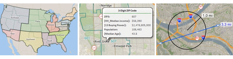
The US Census boundaries (e.g., Tracts, Counties, MCDs, MSAs, States) and the 3- and 5-digit ZIP code areas that come with Maptitude contain some or all of several demographic profiles from a variety of data providers. These sources include the 2010 Census and the 2014 ACS Census to name a few. These data are available for the USA, Puerto Rico, and the Territories. The ZIP Code, Tract, County, and State layers also include updated buying power (disposable income) figures. Tracts also list updated banking compliance FFIEC data for 2015. The Map Librarian makes it easy to access a series of pre-defined thematic and shaded maps of these data.
Please contact the Maptitude Sales Team with any questions. View our new Maptitude 2016 videos here.
Caliper Corporation develops state-of-the-art Geographic Information Systems (GIS) software. With a focus on usability, Maptitude is designed to be a cost-effective, professional mapping software product. Maptitude enables organizations to leverage their location-based data to improve decision making and planning, while minimizing expenditure through competitively priced solutions.
Caliper is a privately held corporation and is a leading developer of mapping, redistricting, transportation, and GIS software.
