Asian Surveying & Mapping
Breaking News
Safran, SatSure partner to develop geospatial intelligence solutions for India
French aerospace giant Safran Electronics & Defense and Indian...
Singapore unveils road map to help develop international business standards and conformance
Singapore has unveiled plans to help develop international standards...
Adelaide University to run space and defence venture launchpad ahead of Australian Space Forum
Adelaide University’s Innovation & Collaboration Centre (ICC) will deliver...
Japan’s H3 rocket returns to space with successful launch after December setback
Japan’s flagship H3 rocket has returned to flight six...
KONGSBERG accelerates seabed mapping developments with Ocean Exploration Trust expedition aboard Exploration Vessel Nautilus
KONGSBERG and the Ocean Exploration Trust (OET) are set...
Russian satellites linked to mysterious GPS disruptions across several countries
Since 2019, GPS signals across Europe, Greenland and Canada...
Isro’s Bahubali LVM3 that launched Chandrayaan-3 to be handed to private sector
IN-SPACe has invited Indian companies to take over the...
India to host 13th UN Global Geospatial Information Management Asia-Pacific Conference
India is hosting the 13th United Nations Global Geospatial...
Unseenlabs’ BRO-22 to Become the First Foreign Private Satellite Launched Aboard Japan’s H3 Launch Vehicle
Scheduled for June 10, between 09:53 and 11:52 a.m....
PLD Space increases investment in its Launch Complex at the Guiana Space Centre (CSG) to €35M, strengthening Europe’s sovereign space infrastructure
The investment is expected to generate approximately €21 million...

December 21st, 2010
SuperGeo Awarded Geospatial Excellence Award at Geospatial World Forum 2011

ATIS

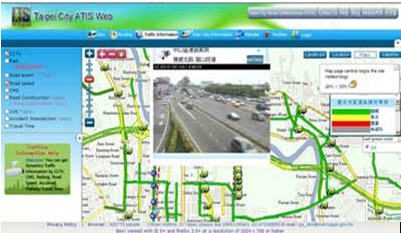
“These are premier private awards, commemorating the excellence and advancement in the field of geospatial.” indicates GIS Development. The application developed by SuperGeo has successfully shown the outstanding usage of geospatial technologies in transportation and traffic management. The project was authorized by Taipei City Government, which provides many kinds of traffic information, such as subway services, parking lots, road speeds, and CCTV, from many sectors. SuperGeo Technologies developed a WebGIS application integrating rich traffic data from dissimilar resources on the same platform. The GIS Web can display complex traffic data for all the public in real time conveniently.

The application used SuperWebGIS, the Internet map server software developed by SuperGeo Technologies, as the user interface platform. Organizations can deliver dynamic maps and share geospatial data via the Web promptly by the software.

The WebGIS application has demonstrated how GIS technologies can help the management combine diversified types of real-time traffic information in one platform easily.  

More information of ATIS Web is available at www.supergeotek.com/ Library_2_201005.aspx More information of the Award: http://geospatialworldforum.org/2011/conference/ award.htm