Asian Surveying & Mapping
Breaking News
Intermap Announces $1 Million Program in Malaysia and Business Updates
DENVER – Intermap Technologies (TSX: IMP; OTCQB: ITMSF) (“Intermap” or...
From Kuala Lumpur To Singapore: Malaysia’s High-Speed Rail Resurgence Sparks China’s Pan-Asia Vision
The Malaysian government is once again working on building...
Japan’s Synspective successfully launches fourth SAR satellite
Synspective, the Japanese provider of Satellite/Synthetic Aperture Radar (SAR)...
South Korea’s Joowon Industrial Selects Aeva 4D LiDAR for Automated Power Line Inspection Program
MOUNTAIN VIEW, Calif. & SEONGNAM CITY, South Korea- Aeva®...
Synspective’s SAR Satellite, StriX-3, Successfully Reaches Its Target Orbit and Spreads Its Wings
TOKYO, 2024, March 13 – Synspective Inc., a SAR...
Indian Prime Minister Narendra Modi Commissions Genesys Digital Twin Map Stack in His Parliamentary Constituency
Mumbai: The Prime Minister of India, Mr. Narendra Modi, recently...
Geo Connect Asia 2024 to unveil geospatial’s transformative power
Geo Connect Asia (GCA) is set to return to...
Iran launches ‘domestically developed’ imaging satellite from Russia
The launch of Pars 1 is fourth this year,...
Astranis relocating hobbled debut satellite from Alaska to Asia
TAMPA, Fla. — Astranis is moving its debut satellite...
Asia space race heats up as China, Japan and India reach for the stars
After another year of US aeronautics company SpaceX dominating...
Kinman

For many years, Kinmen National Park has collected a large sum of geographic data related to this land. However, in some cases, the data format fails to conform to the system for data coordinating, thus seriously affecting the efficiency of the data management. To optimize the management of land resources and to maintain public facilities in Kinmen National Park, the administration decided to establish a Geographic Information System (GIS).

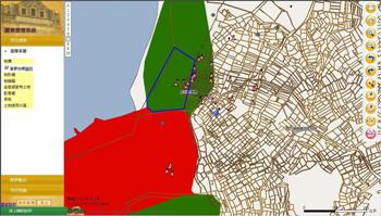
“Kinmen National Park Spatial Data Management GIS” is a management system based on SuperWebGIS, the Internet Map Server software developed by SuperGeo Technologies. It contains five major functions, including query and position, user account management, file management, data output and map data display.

By utilizing substantial map resources and WebGIS technologies, this system can notably improve the management regarding the spatial data of Kinmen National Park, such as map display, query and position with map and text, output of map and data. With the “Kinmen National Park Spatial Data Management GIS” system, the staff of the national park can easily and properly manage the land resources on a unified platform. Moreover, the recreation quality is anticipated to gain considerable elevation in the long term.

More information is available at http://www.supergeotek.com/Library_2_201103.aspx