Vaughan, Ontario, CANADA – October 2, 2025 — Teledyne Optech announced its participation at INTERGEO 2025, taking place in Frankfurt, Germany from October 7–9, 2025. At Hall 12.0, Stand 0C067, Optech will showcase its robust portfolio of solutions designed for topographic and marine mapping, and electric utility inspection. With seamless integration of industry-leading hardware and software workflows, Teledyne Optech delivers comprehensive, real-time mapping insights that set a new standard in geospatial innovation.
Visit Teledyne Optech at stand 0C067 to get an exclusive first look at the latest geospatial innovations
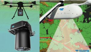
Featured technologies will include Fathom, a topo-bathymetric airborne lidar system, designed for comprehensive data integration of topo lidar, bathy lidar, and a multispectral camera capturing the complete coastal scene—from dry land to below water. Also on display will be EchoONE, Optech’s smallest lidar sensor to date, at just 1.65 kg, combining long-range performance with NDAA compliance and real-time generation of fully georeferenced, undecimated point clouds. Visitors will also discover Network Surveyor, powered by Galaxy Edge, and designed to meet the time constraints of electric utilities, featuring real-time processing and an advanced software analytics stack for utility operators.
Visitors are invited to an exclusive first look at a new compact lidar sensor, designed for integration in modern wing and belly pods. Rapidly deployable in lightweight aircraft and helicopters, this sensor delivers the highest resolution in its class. Engineered to exceed industry standards, it is ideally suited for mapping projects, utility asset management, and vegetation monitoring. Join Teledyne Optech on Tuesday, October 7, from 4pm to 6pm at the stand for light refreshments and to learn more.
The booth will also showcase Teledyne Marine’s sonar and software solutions customized for marine infrastructure projects, including dredging, offshore wind, and port and harbor operations. Live demonstrations of Teledyne FLIR IIS’ field-proven, spatial accuracy (±2 mm accuracy at 10 m distance) spherical imaging camera Ladybug®6, will be available.
Speaker Spotlight
Tuesday, October 7, 12:50 PM – 1:10 PM
Beyond Resolution: Advancing Mobile Mapping Through Spherical Imaging Innovation
Mike Lee, Director of Product Management, Teledyne FLIR IIS
Teledyne Optech is a world leader in high-accuracy lidar solutions and productivity-enhancing real-time workflows. With operations and staff worldwide, Teledyne Optech offers solutions for topographic and marine mapping, defense and electric utility inspection.
