Vaughan, Ontario, CANADA – February 27, 2025 – Teledyne Geospatial is pleased to congratulate Tetra Tech on their remarkable achievement of winning three prestigious MAPPS Awards for a single project using the Teledyne Optech CZMIL SuperNova. The awards include the MAPPS Award for Airborne Acquisition and Processing, the MAPPS Member Choice Award, and the MAPPS Grand Award.

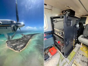
An Aero Commander flying over Betio, Tarawa; (Right) The Optech CZMIL SuperNova installed in the aircraft
The project involved a comprehensive hydrographic survey in the Republic of Kiribati in the Central Pacific. The infrastructure funded project was Tetra Tech’s first large-scale endeavor using the CZMIL SuperNova. The technology used in this project included the CZMIL SuperNova, Starlink for remote network access, Garmin satellite messengers, and a solar panel array to support power needs.
Eric Woolery, Tetra Tech’s Airborne Acquisition Manager, shared his experience: “Working for the Kiribati Nation was a rare opportunity to work with native islanders to safeguard their future against changing coastlines and sea levels. Given that it is one of the lowest-lying nations in the world, a complete hydrographic survey will prove to be a vital tool to help plan economic growth, improve maritime safety, and increase coastal resilience. This assignment has so far been the highlight of my career, and I feel fortunate to have contributed to the Kiribati efforts. The CZMIL SuperNova was particularly well-suited for the clear water and bright white sea bottom of Kiribati, ranging from hundreds of feet deep to very shallow water.”
Jean Jacques Dupont, Vice President Optech, added: “We are thrilled to see the CZMIL SuperNova recognized for its technological innovation and critical role in Tetra Tech’s successful project in Kiribati. This project exemplifies the capabilities of the CZMIL SuperNova in challenging environments and highlights the importance of our collaborative efforts with Tetra Tech. It is a pleasure for us at Teledyne Optech to work with such a talented team at Tetra Tech. We wish their team many more successful topo-bathymetric projects with CZMIL SuperNova.”
Tetra Tech has utilized the CZMIL SuperNova in various environments, from coastal to freshwater and riverine acquisitions. Notably, they achieved the highest elevation data acquisition to date with the CZMIL SuperNova at 11,000 feet during their Blue River project in Colorado.
The CZMIL SuperNova was awarded the MAPPS Geospatial Excellence Award for Technology Innovation in 2022, solidifying its position as a leading technology in the geospatial industry.
Tetra Tech is the leader in water, environment, and sustainable infrastructure, providing high-end consulting and engineering services for projects worldwide. With 30,000 employees working together, Tetra Tech provides clear solutions to complex problems by Leading with Science® to address the entire water cycle, protect and restore the environment, design sustainable and resilient infrastructure, and support the clean energy transition. For more information about Tetra Tech, please visit tetratech.com or follow us on LinkedIn and Facebook.
Teledyne Geospatial unifies the hardware and software expertise of both Teledyne CARIS and Teledyne Optech. The new group provides customers with innovative integrated solutions. Offerings include turnkey systems, lidar and sonar integrated workflows and a range of systems and solutions that support holistic, precision data collection.