USC Spatial Sciences invites students, young professionals, and industry leaders in the geospatial industry to gain insights on GIS trends and network at the 2023 Los Angeles Geospatial Summit.
Full Summit Details HERE
FOR IMMEDIATE RELEASE (Los Angeles, CA) – John P. Wilson, Professor and Founding Director of the USC Spatial Sciences Institute (SSI) has announced the details of its 13th annual hallmark conference: The 2023 Los Angeles Geospatial Summit taking place at the USC Hotel on Friday, February 24, 2023 from 8:30 a.m. to 3:30 p.m. PST.
“We know that students, young professionals and industry leaders, especially in a time of great change, great challenges, and great opportunity, are eager to connect and feed off the energy of active learning in person,” said Wilson. “This year our program explores the growing potential for deploying geospatial data to resolve pressing issues related to environmental sustainability, community resiliency and business productivity — now and for the future.”
The opening session will feature a keynote address on “Navigating Geospatial Growth” by Manish Dasaur, Managing Director, Chief Data & Analytics Officer, Accenture – Applied Intelligence.
Following Dasaur’s keynote, a panel of experts will discuss the trends and changes ahead in the geospatial industry. Wilson will moderate the discussion with Sarah Battersby, Ph.D., Principal Research Scientist, Tableau, and Conan Cheng, Chief Operations Officer, Los Angeles Metro.
The first afternoon session will focus on developments in spatial data acquisition with remote sensing. The speakers in this session will include Yi Qi, SSI Associate Professor (Teaching); Melissa Christie, Senior Account Manager, West Coast, NV5 Geospatial; Canserina Kurnia, Senior Solution Engineer, Education, Esri, and a representative Planet.com.
Thomas Horan, H. Jess and Donna Senecal Endowed Dean’s Chair and Dean, School of Business, University of Redlands, will moderate a session on “Place, Business and Equity.” This session delves into how geospatial sciences and technologies can increase the value proposition for businesses, organizations and local governments in simultaneously achieving goals that promote economic, environmental and social well-being. The panelists will be Kayla de la Haye, Associate Professor of Population and Public Health Sciences, Keck School of Medicine of USC; Michael Ann Lane, Global Education and Inside Sales Manager, Hexagon Geospatial; and Andrew Haney, Senior Geospatial Consultant, 1898 & Co., a part of Burns & McDonnell.
A new element in this year’s Summit is the student StoryMap competition sponsored by Esri. In the past, students have participated in a poster competition.
Undergraduate and graduate students from local GIS programs will present their StoryMaps and compete for awards in in three categories:
1) most innovative use of technology
2) most compelling communication using maps
3) most suitably applied methodology or analysis
“The student research presentations shared at the Summit consistently provide new and innovative ideas. By shifting the format of presentations from posters to StoryMaps, we increase the reach of the possible, by widening the audience and enabling a dynamic and rich paradigm to share the narrative of projects. As the geospatial world shifts towards a more connected and cloud-first approach, so should our student presentations,” said Andrew Haglund, Esri Higher Education Account Manager.
Winners in each category will receive prizes provided by Esri and will be featured in Esri and SSI post-Summit communications.
Three students selected by a faculty committee will have the opportunity to present their research in a lightning talk session sponsored by Maxar. Barry C. Tilton, Technical Evangelist, Strategic Growth, Maxar, will moderate the session, in which the students will discuss their work with a panel of expert respondents.
Students participating in the StoryMap and lightning talk sessions are coming from GIS academic programs that include California State University, Long Beach; the University of Redlands; and the University of Southern California.
An annual highlight of the Summit program is the lunchtime “Knowledge Network,” during which Summit participants network with representatives of leading companies and organizations. This year’s roster of Knowledge Network participants include: Accenture; Burns & McDonnell; California Geographic Information Association (CGIA); California State University, Long Beach; California URISA; Eclipse Mapping and GIS; Esri; HRL Labs, Maxar Technologies; Southern California Association of Governments (SCAG); Tableau; U.S. Geospatial Intelligence Foundation; University of Redlands; USC Libraries; USC Spatial Sciences Institute and Women in GIS.
This year’s Summit program will conclude with a networking reception for all Summit participants.
Summit participants will also have the ability to access prerecorded technical workshops presented by the Summit Gold Sponsors. This year’s Gold Sponsors to date include Accenture, Eclipse Mapping and GIS, Esri, HRL Labs, Maxar, the University of Redlands, and the USC Spatial Sciences Institute.
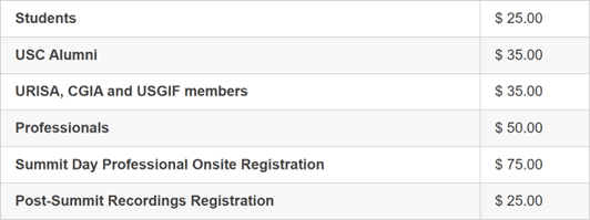
Those interested in viewing recordings of the main stage sessions, the technical workshops and the poster gallery after the Summit date can register now for a special online registration rate of $25. USC alumni and members of CGIA, the United States Geospatial Intelligence Foundation, and URISA can take advantage of a discounted registration rate.
“We thank our Gold Sponsors as well as our Bronze Sponsors to date – Burns & McDonnell, the California Geographic Information Association (CGIA); and the California State University, Long Beach Department of Geography – for their support in presenting a program featuring cutting-edge industry trends,” Wilson said. “We hope you will join us for a day of stimulating interactions.”
Summit Registration:
Friday, February 24, 2023
8:30 a.m. – 3:30 p.m.
GIS and geospatial sciences students from any college or university, as well as industry professionals, can register for the Summit here.
A detailed program breakdown of the Summit can be found here.
Registration Rates:
About USC Spatial Sciences Institute:
Since its founding in 2010, the USC Spatial Sciences Institute has been using the power of connecting place, space, and time to help address global challenges like population growth, environmental sustainability, and human well-being. Housed in the USC Dornsife College of Letters, Arts and Sciences, the research and academic programs of the Spatial Sciences Institute contribute to the rapidly evolving body of geospatial knowledge and are innovating ways to empower decision-makers with the analysis, modeling, and visualization of location-based data. As the hub of spatial-related academic programs at USC, the Spatial Sciences Institute is unique in offering interdisciplinary courses and degrees at every higher educational level.
For more information about our research and academic programs, please visit spatial.usc.edu.
