TOKYO – Hexagon’s Safety, Infrastructure & Geospatial division and OSASI Technos Inc. announced a partnership to deliver next-generation disaster management and monitoring solutions. The wide area remote monitoring systems with 3D visualization capabilities will allow governments to detect, predict and simulate impending disasters, enabling them to better plan for and respond to emergency events. The news was announced today at a signing ceremony during the Belgian Economic Mission to Japan.
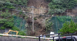
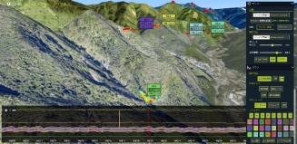
The partnership brings together OSASI’s advanced on-site sensors and monitoring solutions with the real-time situational awareness and location intelligence capabilities of Hexagon’s Luciad Portfolio. Combining on-site information, such as rainfall measurements and river water levels, with maps, 3D data and other information from third-party sources will provide advanced visualization and real-time analysis to unlock insights for predicting and detecting landslides, mudflows, slope failures and other disasters faster.
“At Hexagon, our goal is to enable safer, smarter cities by providing governments and other organizations the tools they need to protect residents and visitors,” said Dirk Wagemans, senior vice president, commercial business, Hexagon’s Safety, Infrastructure & Geospatial division. “By partnering with OSASI to deliver next-generation disaster management and monitoring solutions, governments have greater access to information and insights that could mitigate impacts of disasters and save lives.”
“OSASI has been developing measurement instruments for the field and providing monitoring solutions for observation points through its information sharing services,” said Maki Yano, president of OSASI Technos Inc. “With this new partnership, we aim to develop a new disaster monitoring solution for a wider area based on time-series data from the past to the present, integrating weather, water and geological data by using Luciad’s advanced visualization technology. By providing society with unprecedented intuitive information, we hope to contribute to disaster prediction and realize a safer society.”
Learn more about Hexagon’s Luciad Portfolio and OSASI’s remote surveillance products.
Contacts:
HexagonEmily ArnoldGlobal Communications ManagerTel: +1 256.730.2582Email: [email protected]
OSASI Technos Inc.65-3, Hongu-cho, Kochi-shi, Kochi780-0945, JapanTel: +81 88.850.0535Email: [email protected]Url: https://www.osasi.co.jp/en/
Hexagon is a global leader in digital reality solutions, combining sensor, software and autonomous technologies. We are putting data to work to boost efficiency, productivity, quality and safety across industrial, manufacturing, infrastructure, public sector and mobility applications. Our technologies are shaping production and people-related ecosystems to become increasingly connected and autonomous – ensuring a scalable, sustainable future.
Hexagon’s Safety, Infrastructure & Geospatial division improves the resilience and sustainability of the world’s critical services and infrastructure. Our solutions turn complex data about people, places and assets into meaningful information and capabilities for better, faster decision-making in public safety, utilities, defense, transportation and government.
Hexagon (Nasdaq Stockholm: HEXA B) has approximately 23,000 employees in 50 countries and net sales of approximately 4.3bn EUR. Learn more at hexagon.com and follow us @HexagonAB.
With the catchphrase “Communicating the Voice of the Earth,” OSASI designs and develops measuring instruments based on its unique technology and know-how to protect irreplaceable lives and assets from natural disasters such as landslides, floods, and sediment disasters.
With the development of communication infrastructure, there is a growing demand for the construction of remote monitoring systems for disasters and emergencies.
OSASI is working daily to meet the diversifying needs of society by providing cloud monitoring services that allow data to be checked on the Web.
OSASI will continue to strive to provide better products with reliable technology to gain further trust from their customers.
