Demos focus on “How to Get Started with Digital Twins”
Montreal, Canada — Presagis, a global leader in 3D advanced modelling and simulation software, will offer sneak peek demonstrations into new capabilities of its VELOCITY 5D (V5D) platform at the 2022 Esri User Conference in San Diego. Scheduled for full release this fall, V5D is a fast, flexible, and scalable software ecosystem that automatically converts 2D and 3D GIS data into realistic information-rich digital twins to deliver real-time location intelligence and improved decision making.
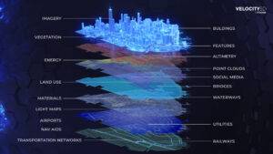
VELOCITY 5D can ingest a wide range of GIS data and rapidly transform it into a large-scale, accurate and realistic digital twin – with context.
“V5D solves two major challenges facing GIS professionals overwhelmed by the digital transformation of geospatial data,” said Jean-Michel Briere, President of Presagis. “First, V5D easily ingests massive GIS data sets, accelerating information extraction and delivery through automation for fast conversion into accurate 3D digital twins. Then, the cloud-based VELOCITY 5D platform enables users to visualize complex simulation scenarios to derive context from their 3D data sets, all the while leveraging game engine technology for visualization.”
Context expands the digital twin beyond the dimensions of area, space, and time. V5D applies artificial intelligence to extract context, the fifth dimension (5D), from complex geospatial digital twins to reveal patterns of life, human interactions, crowd behaviors, vehicle traffic movement and other relationships. This enables users to better interpret the dynamic world around them and model for future situations.
“V5D can generate a nation-wide high-fidelity digital twin from country-sized GIS data sets in hours, not days, and immediately begin running simulation, visualization, planning and mapping scenarios,” said Stuart Blundell, Presagis Strategic Alliance Manager. “The speed, realism, and scalability of V5D for digital twin generation are unmatched in the geospatial industry today.”
Presagis will conduct demonstrations of V5D in booth #2207 at the Esri User Conference, which runs July 11-15, 2022. With a theme of “How to Get Started with Digital Twins,” the V5D demos will focus on building digital twins and virtual environments from the GIS data that Esri users already have. Demos will be customized to highlight solutions in a variety of common digital twin application areas – Smart City Management, Large Area Mapping, Defense, Infrastructure/Utility Security, Asset Tracking, Disaster Preparedness, and Urban Planning.
Booth visitors will experience new V5D capabilities that have been recently developed:
Esri conference attendees will also gain a sneak peek into the Presagis Content-on-Demand portal where a library of synthetic 3D virtual environments can be obtained to complete the digital twin generation for users with limited geospatial data. In addition, Presagis will demonstrate the 3D Environments Add-In application for Esri’s ArcGIS Pro, released recently and now available on the Esri ArcGIS Marketplace.
Visit the Presagis team in booth #2207 at the Esri User Conference. On hand to perform demos and discuss the latest in digital twins and simulation will be Stuart Blundell, Kjell Kolstad, and Scott McAvoy.
To learn more and receive updates about V5D availability, please visit www.velocity5d.com.
About Presagis: Presagis is a global leader providing commercial modeling, simulation and embedded software solutions to the aerospace, defense, security, and critical infrastructure markets. Presagis combines an open simulation development framework with expert professional services to help customers build vast dynamic virtual environments, deliver game-quality immersive simulations – all the while streamlining workflows and reducing risks. Presagis is also at the forefront of avionics software design for certifiable cockpit displays, and, together with its modeling and simulation offerings, serves hundreds of customers worldwide, including many of the world’s most respected organizations such as Boeing, Lockheed Martin, Airbus, BAE Systems, and CAE. For more information, visit www.presagis.com.
